Over the last 3 years I have driven between Kansas City and Binghamton, New York twelve times, that adds up to around 15,600 miles of driving in total. It’s a lot of time on the road, and in the last few weeks I’ve begun to think of this period in my life as my Years of Wandering, a period when I have been practically migratory in how I’ve moved across the country so often. Surely at this point the postal workers in Binghamton and Kansas City recognize my name for how frequently I’m asking my mail to be forwarded from one address to another. Still, I am in a far better position professionally today than I was after my first master’s degree in 2016. And looking ahead now, the future really is bright for me. I’ve got a lot of opportunities over the horizon.
With all this in mind, I woke up at the reveille of my 06:45 alarm on Friday, 29 July 2022, as is usual, and ruminated on a strange dream I had been having involving, people singing the Internationale while making strange hand gestures and being overly polite, all as a part of a protest over fish. Must’ve been the wine the evening before. Regardless, I woke up that morning knowing exactly what I needed to do: it was time to strip my bed, start my regular morning routine, and begin packing up the car for the next Long Drive East.
To date this drive is the earliest I’ve ever left to return to Binghamton for the Fall semester. Its predecessor in that record was the original Long Drive East on 1 and 2 August 2019, after which I decided I would never again make that trip so early in August again. I intended to keep that promise, even through the period of 14-day quarantines in 2020, yet here I was, on the 29th of July packing the car for the Long Drive East, a drive that would end in a muggy humid valley in Upstate New York that feels about as far from home as it could be while still being in the Lower 48. So, after a quick breakfast of sourdough French toast, scrambled eggs, and hash browns with some friends, I left home at 10:00, bound for my first refueling stop in St. Louis.
The normal Long Drive East has four refueling stops, one every four hours. Typically, they are St. Louis, Indianapolis, Columbus, and Erie. That is if I take the fastest out of the possible 10 different routes. In this instance, I intended to keep to form and barrel my way across Missouri without stopping between Kansas City and St. Louis, so as to get the trip off to a strong start, and maybe to make better time at my overnight stop. But, as things have happened so often this summer, the first day of the trip didn’t quite go to plan. Rather than making it all the way to St. Louis without stopping I decided midway across the state to make a lunch stop in Columbia, home of Mizzou (the University of Missouri to the rest of humanity not from the Midwest). Already by that point I was beginning to feel pretty tired, and knew I needed at least a few minutes of a break. With that in mind, I made an early stop, and shrugged it off, opening the door for even more unscheduled stops over the rest of the trip to come.
This particular Long Drive East was different from every other one that I’ve done over the past few years. Sometimes, I might include a day or two of sightseeing along the way, as an extra bribe to myself to go through with driving so far for so long. The last time I did that was in January 2020 when I stopped in Pittsburgh for a couple days to see the Carnegie Museums. In the years since I’ve allowed myself half-day stops here and there, like at the Cleveland Museum of Natural History in August 2021. In all of those occasions I rarely detoured from the general Great Lakes region that lies between the Great Plains where Kansas City blooms and the Appalachians where Binghamton is nestled among those low mountains along the banks of the ancient Susquehanna River.
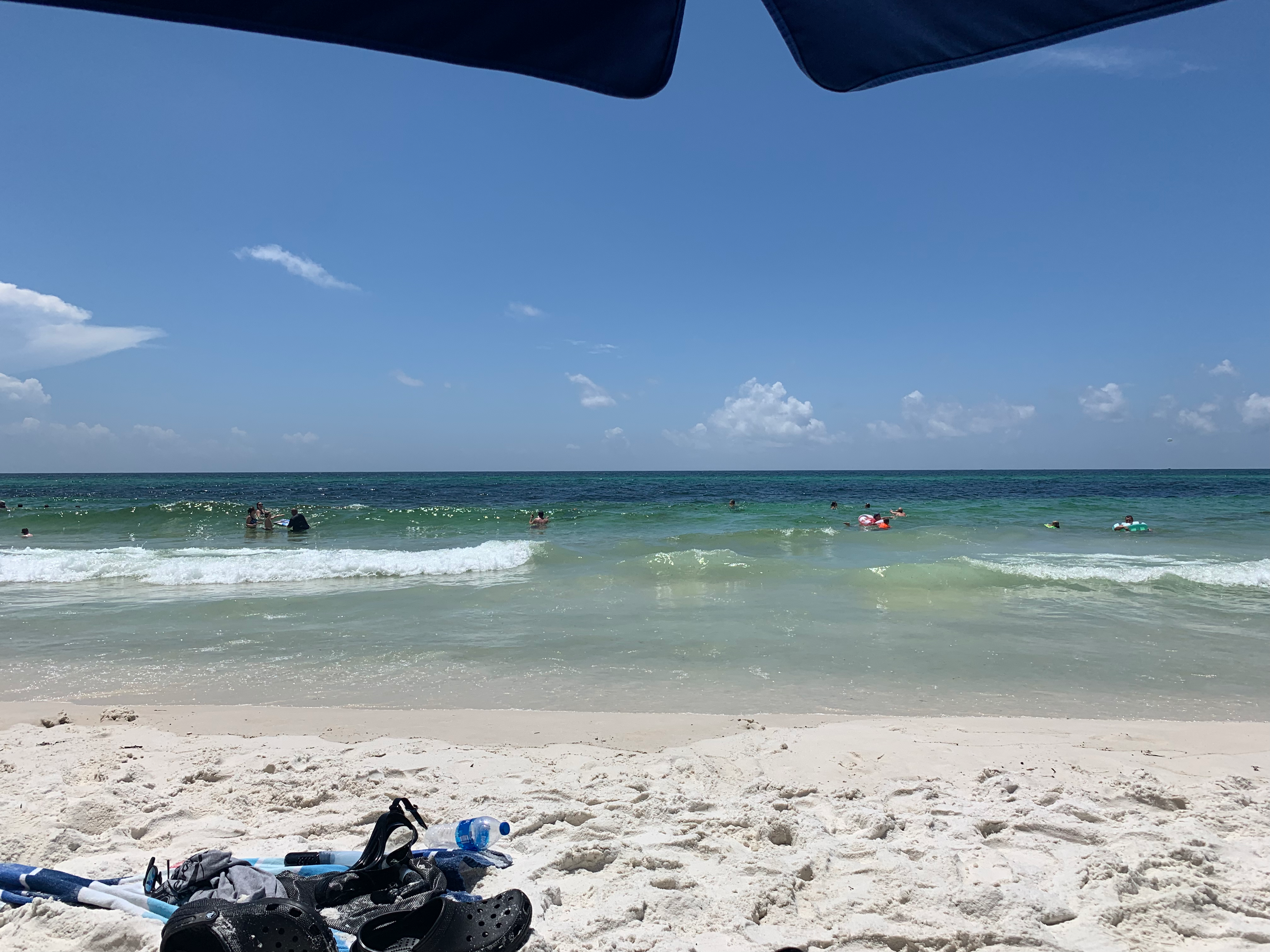
This time I was taking a long way around, not exactly what I’d call “the long way around”––that would be driving to Binghamton via Alaska––instead, I planned to return to Binghamton via the South, the one region of the country (besides Alaska and Hawaii) that I’ve spent the least amount of time in. Why would I add an extra 1,430 miles (2,301.36 km) to my route just to do a bit of sightseeing? Family, that’s why. This year my family decided to hold a reunion in Destin, Florida, a small resort town on the Emerald Coast of the Gulf of Mexico that lies about halfway between the larger Northern Florida cities of Pensacola and Panama City.
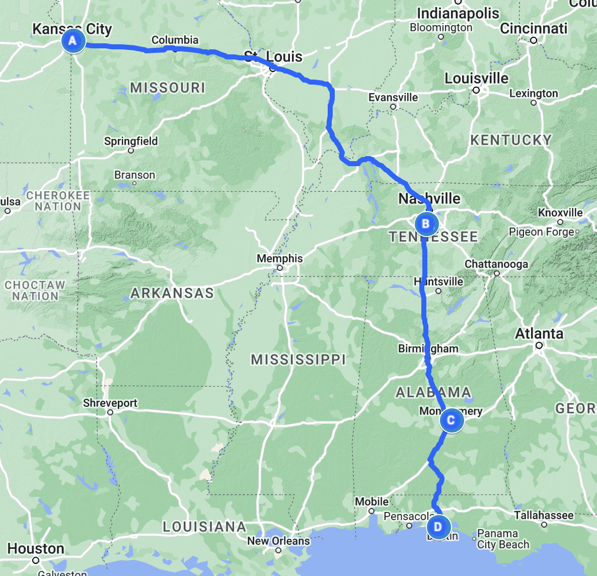
Of the 24 of us who went to Destin this Summer about half made the trip by air along various routes, while the other half of us drove. I decided from the first moment I started planning this trip that I wanted to stick to the interstates as much as possible, seeing as I memorized most of those over years of staring at maps during road trips as a kid between Chicago and Kansas City. Most of the drivers chose to take a slightly faster route on US Highways through the Ozarks stopping overnight in Memphis and Tupelo, Mississippi (Elvis’s two hometowns). In my case, my goal for the first night was Franklin, Tennessee, a suburb south of Nashville along I-65. So, naturally as I drove across Missouri, I was repeating from time to time the general route I was following on that first day: I-70, I-64, I-57, I-24, I-65. As long as I kept those numbers in mind, I knew I’d make it to Franklin eventually.
I arrived in St. Louis around 13:30, about 2 hours later than I usually would on a Long Drive East. Granted, I also left Kansas City 2 hours later than usual, choosing that wonderful breakfast at Eggtc. over the typical simpler breakfast at home or the quick sandwich & doughnuts that I’d normally pick for such a trip. In the days before I left, the St. Louis area had been badly flooded by heavy rains, with some places in St. Charles County even seeing a foot of rain (30 cm) fall in the course of a day. The reports showed homes inundated, metro stations submerged beneath 21st century ponds, and highways deep under water. I was concerned that the aftereffects of the flooding might close some of the highways I needed to take, particularly I-70 in St. Charles County and I-64 across St. Louis County and City, but thankfully it was smooth sailing the entire way to the Arch.
I crossed the mighty Mississippi on the Poplar Street Bridge and left Missouri behind for the second state, the state of my birth, Illinois. Now the thing to say about Illinois from the start is that as much as it is the state of my birth, there is a tremendous difference between Chicago and the rest of Illinois, just as there is between any metropolitan area and the rural countryside in between across the United States. So, as much as I do kind of feel at home even there in Southern Illinois, it’s still not exactly the same as the place that I still call my original home a couple hours’ drive to the north of St. Louis. This trip marked the first time I drove southeast out of St. Louis on I-64, which is the main road between St. Louis and Louisville, continuing on from there eventually to Richmond and Hampton Roads, Virginia. I was only on I-64 for a short time, little more than an hour, when in Mt. Vernon, Illinois I left that east-west route and turned south on I-57, a highway I usually encounter in Effingham, Illinois, to head towards the furthest reaches of that state of my birth, to a place I’d long heard of and wondered about.
When I was 5 or 6 my parents bought a beautiful cloth-bound hardcover photographic atlas of the United States that was probably a special millennium edition. I remember the inside cover had a photo of a mountain climber scaling an ice-covered cliff on one of the mountains either out in the Rockies or up in Alaska. But as I drove through the southernmost reaches of Illinois, what came to mind the most was the photo of the Fall colors in Shawnee National Forest, which covers 280,000 acres (1,100 km2) of woodlands near the confluence of the Ohio and Mississippi Rivers. As a child, I always was amazed that there was a national forest in Illinois, I had only ever encountered national forests out in Colorado, and so to me that meant they must be truly wild places with great mountains and old trees and lots of animals. Shawnee National Forest certainly has some hills, the Ozark and Shawnee Hills to be precise, but the years since has tempered my initial surprise through time spent in the national forests of the Appalachians.
I crossed the Ohio at Paducah, entering the Commonwealth of Kentucky. I last visited Kentucky in September 2018 when I attended the Midwest Conference on British Studies at an Embassy Suites in Lexington. My experience of the state this time was largely the same as that time, only I’m happy to report I-24 is far less potholed than I-75 was the last time I drove it between Cincinnati and Lexington. I crossed Kentucky quickly, I-24 crosses only 93 miles in that state before entering Tennessee. While in Kentucky though I did see the first big dark clouds that marked the latest round of flooding, this time not in St. Louis but in Eastern Kentucky.
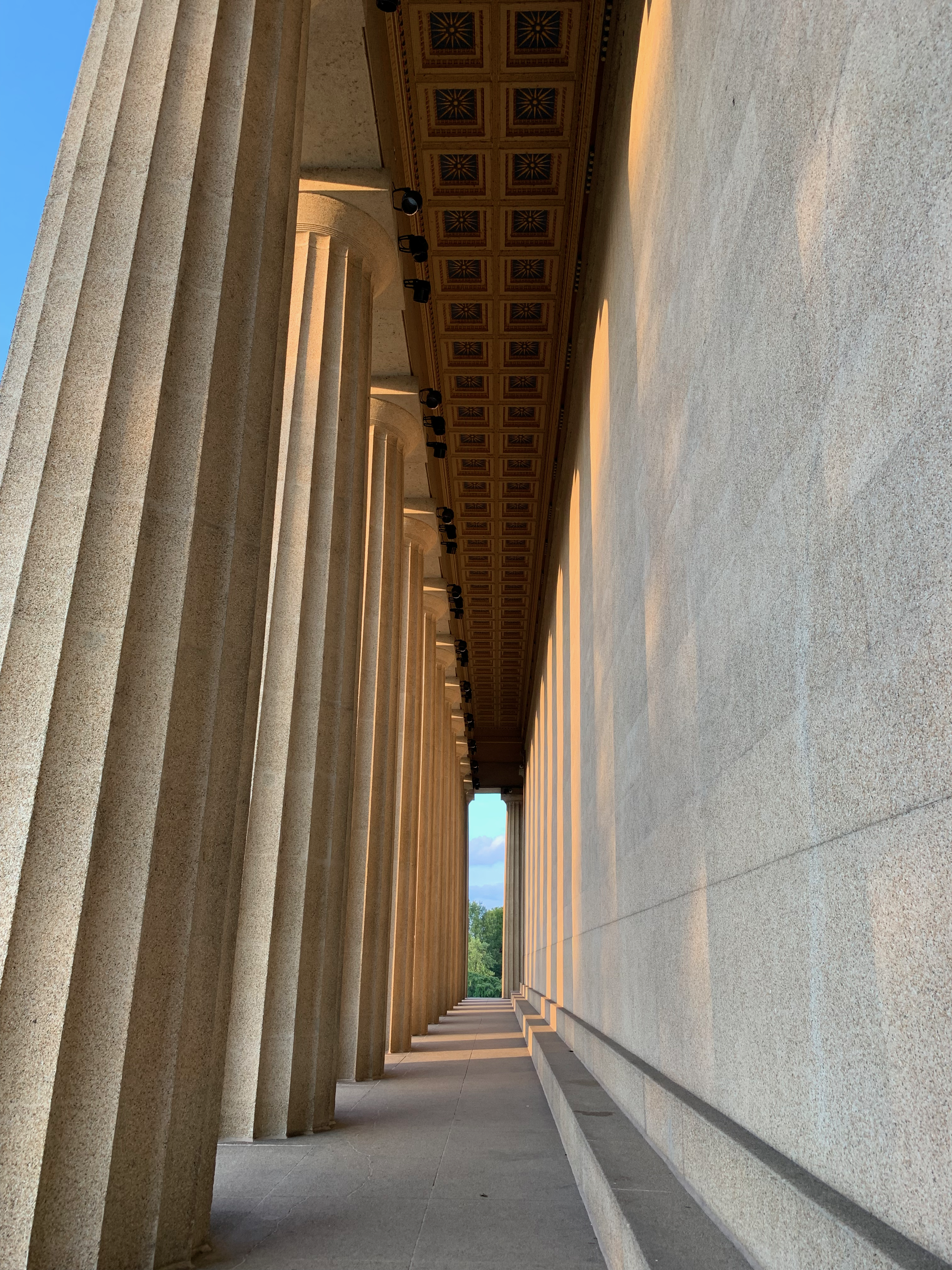
As I left Kentucky for Tennessee, I began to enter a far hillier area that makes up the northern rim of the Nashville Basin, a great bowl surrounding the state capital. Traffic picked up as I descended into the bowl, reaching the I-24/I-65 junction north of Downtown Nashville. Back in Kansas City I had chosen to enter the address of the top site on my tourist list in Nashville into my navigation system, and so I left I-65 early of my hotel for Centennial Park and the Nashville Parthenon. This building is a full-scale replica of the original Parthenon located on the Acropolis in Athens. I arrived at 19:00, sadly a few hours after the interior had closed to visitors, and thus could not enter the building. Nevertheless, I gazed in wonder at the reliefs and ornate ceilings of the porticoes and stoas.
After a quick stop at the Parthenon, I made an even quicker stop at the Tennessee State Capitol, wanting to avoid the ire of the state police for spending too long on their property, and by that point having been on the road for a full 9 hours, I really needed to get to my hotel to sleep. With those two stops in Downtown Nashville done, I returned to I-65 and made quick work of the drive south to Franklin.
The following morning, I woke with my 06:45 alarm and staggered upright after the usual vivid and surreal dreams. There were images of me in quick step striding my way across a white sand beach on the Gulf Coast, dressed in a full business suit beneath the midday Sun. In my left hand my briefcase, my right hand raised aloft trying to catch some phantom bus that was due to roll onto the shore. Riding atop my head was my cat, Kitty, lazily lunging on my scalp as if unconcerned by the precariousness of her position.
I remembered what I had to do and quickly got ready for another day of driving. While the first day had taken me along roads I knew all too well, this day would pass along many roads I’d only ever looked at on the map. I left my hotel in Franklin at 08:00, stopping for a quick breakfast before turning my attention once more to I-65 and the continuing road south. The Tennessee hills glowed in the morning Sun, their green cover of foliage marking the southern end of the great Appalachian Mountains that I knew well in New York.
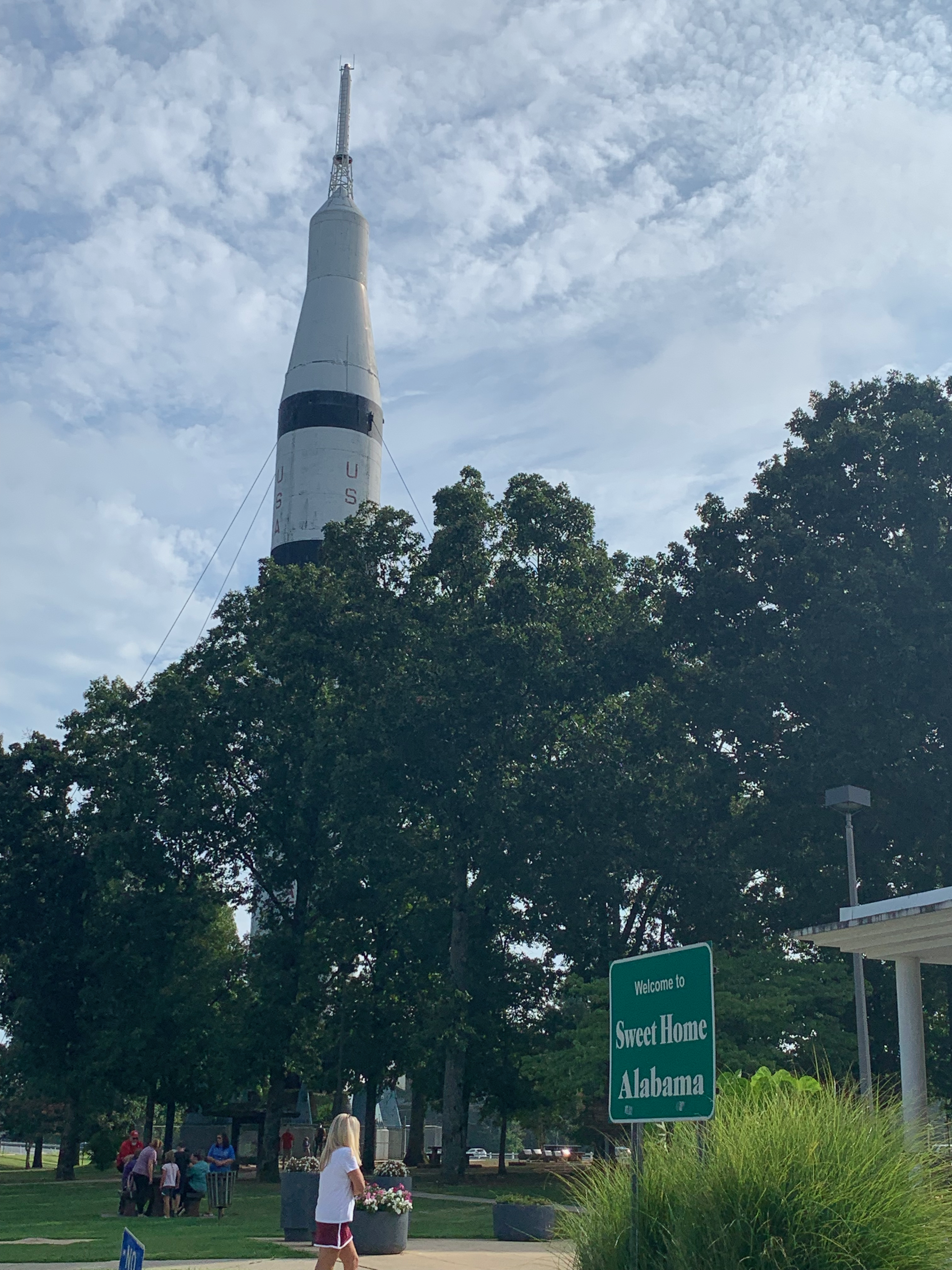
I made quick progress along I-65 to the Alabama border and soon found myself facing a Saturn IB, a NASA rocket built in Huntsville, Alabama. I pulled over into the Alabama Welcome Center parking lot and briskly walked over to the base of the rocket to take some pictures before returning to my own chariot for its continuing voyage rocketing ever southward toward far greener shores.
Alabama struck me as in some ways old fashioned, in other ways brilliant, as in how they included the mile markers on each bridge, a great way of calculating distances as I crossed the Heart of Dixie. After about an hour I entered the great valley where Birmingham was built, the largest city by far in the state. In Birmingham I began to truly notice that I was moving southward as I crossed over Interstate 20.
Here in the US, the Interstate highways are numbered in an ingenious way to help navigation: east-west highways are even numbered with the lower numbered highways in the south and higher numbered in the north, and north-south highways are odd numbered, with the lower numbered in the west and higher numbered in the east. Thus, with Interstates 5 and and 8, San Diego is the 0/0 point of the Interstate system, while Boston with its Interstates 95 and 90 is the exact opposite. There are some exceptions to the rule (I’m looking at you, I-99 in central Pennsylvania and New York), but by and large it’s a rule that’s followed nationwide. So, when I saw the signs for I-20, I knew I was making progress, especially when I started the trip in Kansas City on I-70.
Birmingham seemed like an interesting place, and while I didn’t stop there this time, I wouldn’t be entirely opposed to having a conference there in future years, if that happens. Nevertheless, I passed it on by and continued south toward my first waypoint of the day in the state capitol Montgomery. Yet after leaving Birmingham I was baffled to be stopped by bumper-to-bumper traffic that had occurred for no apparent reason. I sat in the southbound lanes crawling behind semis, RVs, boats on trailers, pickup trucks, and suburban soccer mom tanks (aka minivans) with every state’s license plate imaginable adorning their rear bumpers. The heavy traffic continued for the rest of the day’s drive until I reached the Gulf Coast late that afternoon.
I reached Montgomery just before noon and drove straight to the main site I wanted to visit. The National Memorial for Peace & Justice opened in April 2018 to much press. A review at the time from The Washington Post’s Philip Kennicott called it “one of the most powerful and effective new memorials created in a generation.” I read all about it when it opened, and even looked into how I could travel to Montgomery to visit it. When I did arrive, I wasn’t disappointed. The memorial honors the African American victims of racially motivated lynchings that took place between the end of Reconstruction in 1877 and the beginning of the Civil Rights movement in the 1950s. The memorial is made up of a series of 805 hanging rectangular steel pillars representing each county where an African American was lynched in this country during that 73-year period. I was quiet walking up to the memorial, stunned by the sight of it. I knew what to expect, but I didn’t really grasp the power of that vision until I actually saw it in the flesh. How such racially motivated terror was, and frankly remains so common in this country is sickening.
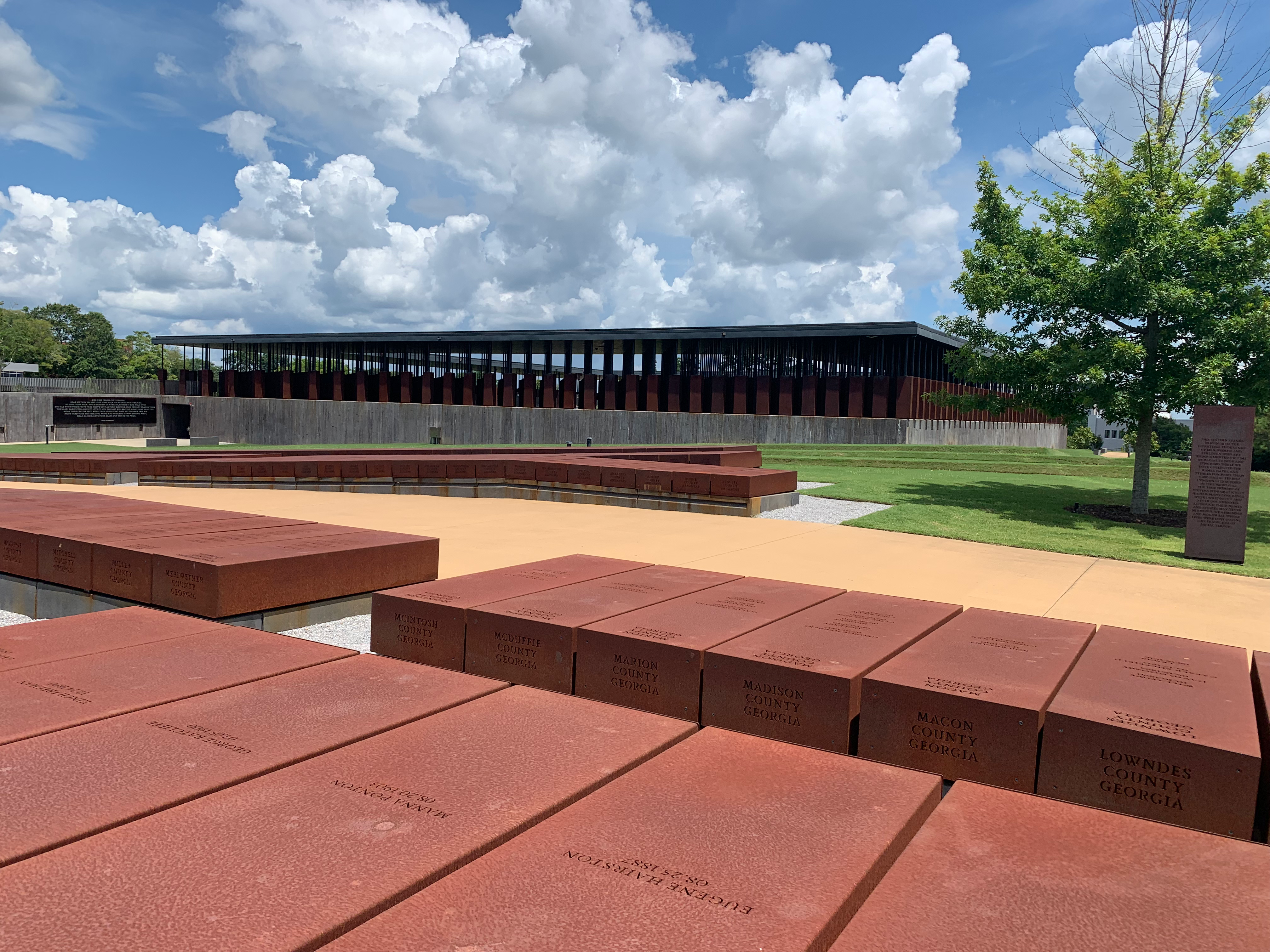
My eyes stayed wide as I gazed first at the pillars that hung along the entry to the memorial and then slowly turning upward as I walked down into the heart of the site, a trench that was dug deep into the ground like some vast communal grave into which all these tormented souls were buried. Some of these pillars have been taken down from their original places aloft and placed on the ground in a series of rows like in a cemetery, those that have are the ones that represent counties that have established their own memorials to mourn those who were murdered this way locally. My own home county––Jackson County, Missouri––was included among those that have erected their own memorials, in our case to a man named Levi Harrington who was murdered on 3 April 1882 on a bridge in the West Bottoms. In June 2020 the monument in question was thrown down the cliffs on the western side of Quality Hill soon after its installation by several unnamed individuals. At this moment of writing, I can’t remember if it was replaced and fixed.
I left the memorial and drove into downtown Montgomery hoping to find lunch and make a stop at the Alabama State Capitol. Yet of all the things that could be confounding the parking situation was what kept me from making more than just the one stop on the capitol grounds. Every parking meter I stopped at had a red “Expired” sign waving like a most unwelcoming of flags before me. So, I decided the best place to risk getting ticketed for illegal parking was the State Capitol itself.
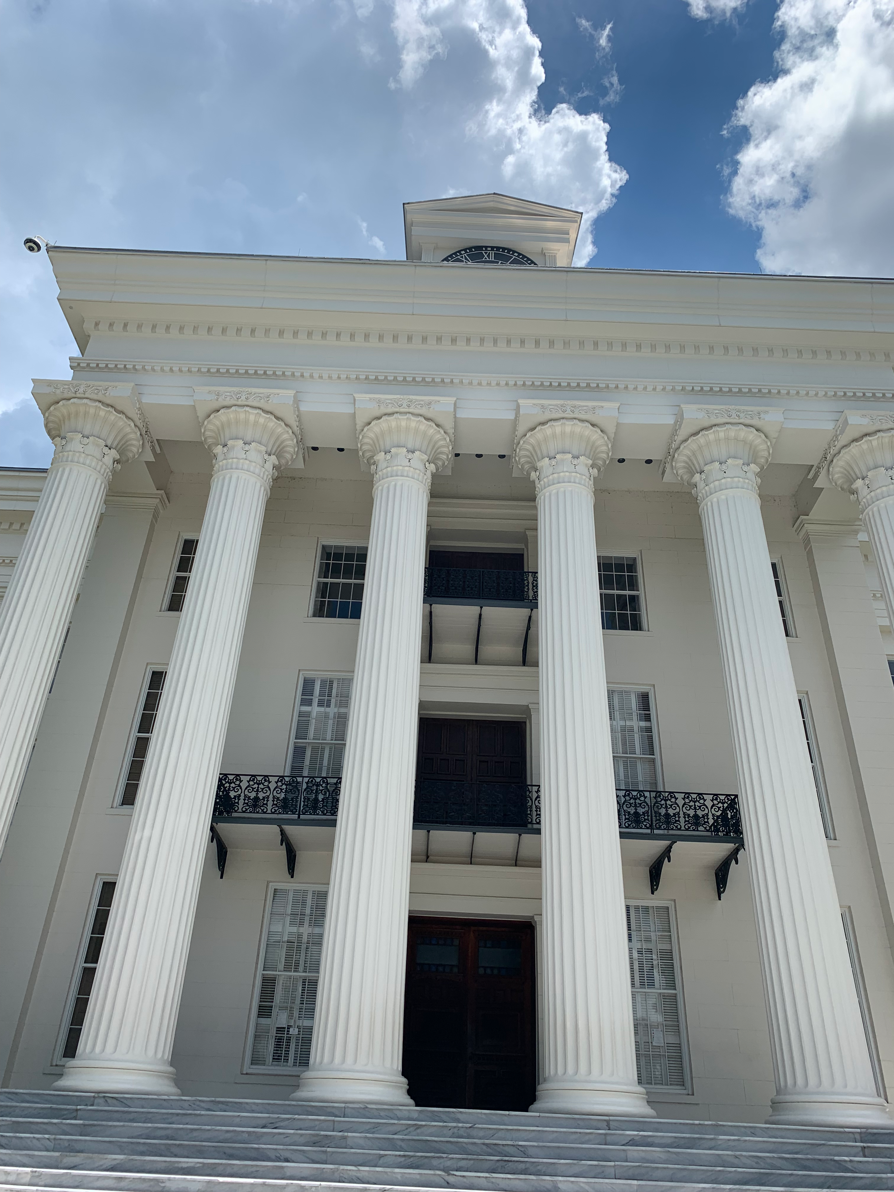
The Alabama State Capitol has a checkered history in my book. On 22 February 1862 it was the scene of the inauguration of Jefferson Davis as President of the Confederate States. While I was taking pictures of the capitol building’s white façade a guard walked over to me and asked, “You should get pictures of the statues as well, like Jefferson Davis over there?” I turned to the guard and quickly replied, admittedly without thought, “I don’t take pictures of traitors.” Alabama to me is the South personified, it was home to the first capital of the Confederacy, and the heart of the old Jim Crow South that perpetuated the evils of the old Southern way of life for generations after they were defeated in battle by the Northerners and Midwesterners. I myself didn’t have any ancestors who fought in the Civil War, they were all either too old or too young for the draft, but I do remember hearing stories of the anger towards the South in the younger generation that lived through that war, whose lives were scarred by the horrors of a war fought over the elites of one half of the country’s inability to consider an entire group of people as anything more than property. This is the reason why I’ve generally avoided the South, especially Alabama, which to me is the beating heart of that infernal system.
I left Montgomery and continued ploughing my way ever southward toward the coast. I followed I-65 for another 90 minutes of steady traffic until turning off and onto a series of smaller country roads at the town of Georgiana, birthplace of Hank Williams (1923–1953) one of the most influential country singer-songwriters of the last century. From there the road took me ever deeper into the hardwood swamp forests and bogs of southern Alabama, typified by the woods of Conecuh National Forest. As I drove through the forest the first sign that I had entered Florida was that the highway name had switched from an Alabama state highway to a Florida one. Naturally at that point I lost my data signal and briefly lost navigation and communication on my car’s computer.
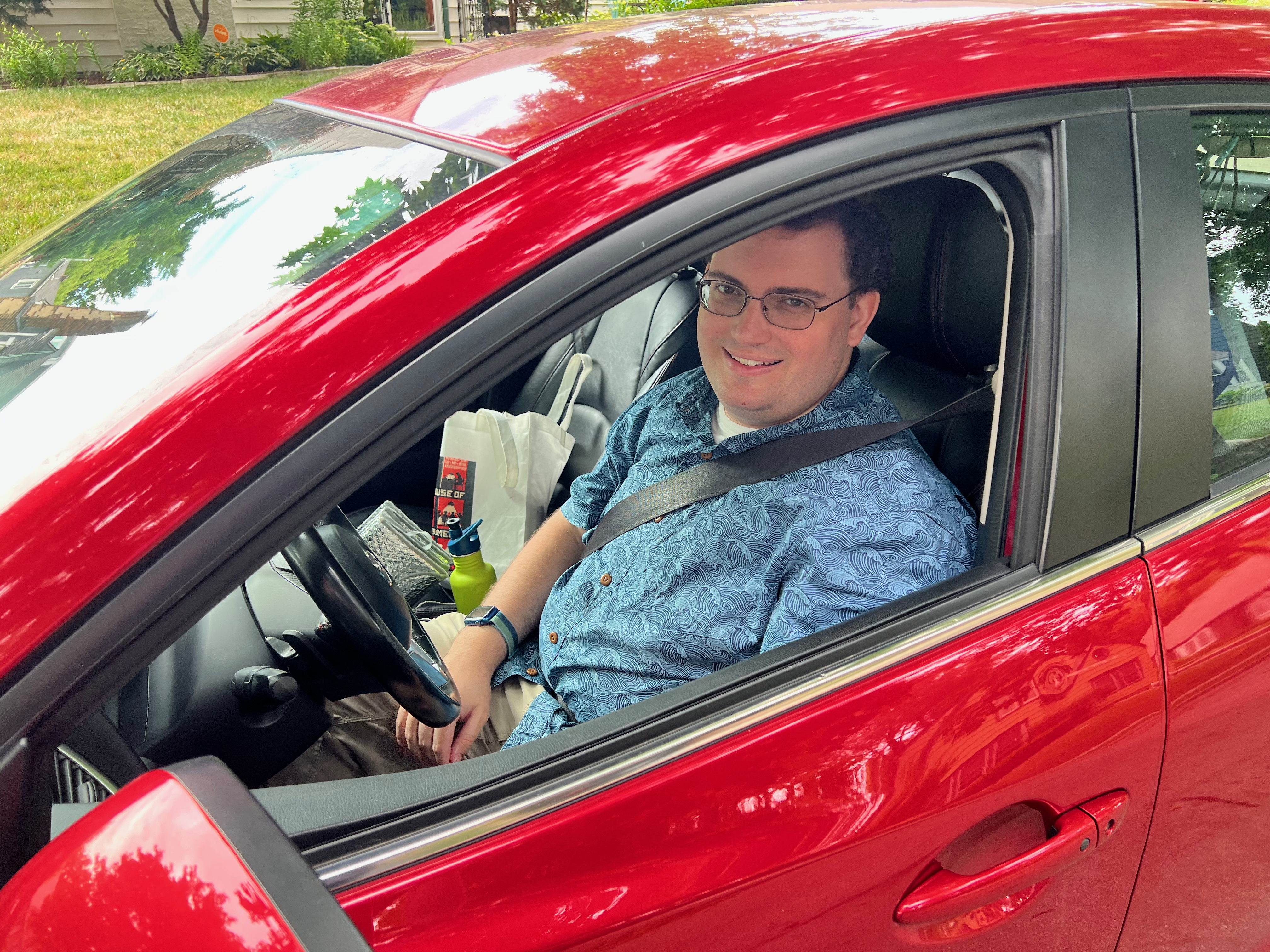
But after a good 15 minutes it all began to return as I left the thick forests of the far northern reaches of the Florida Panhandle and crossed over I-10, better known in California as the Santa Monica Freeway. After another 20 minutes I was in Fort Walton Beach approaching Destin with seemingly nearly everyone else from the Midwest and Deep South. The streets of Fort Walton Beach were packed to the gills, leading to the last mile of the drive taking a full 20 minutes to complete. Regardless, I was now in sight of the Gulf of Mexico, the second arm of the Atlantic I had driven my car, the Mazda Rua, to. It was surely the beginning of a beautiful relationship.