Tag Archives: Seán Kane

Sneezing across the West, Part 2

Click the Instagram logo above to view my archived Instagram story from this trip.

Introduction

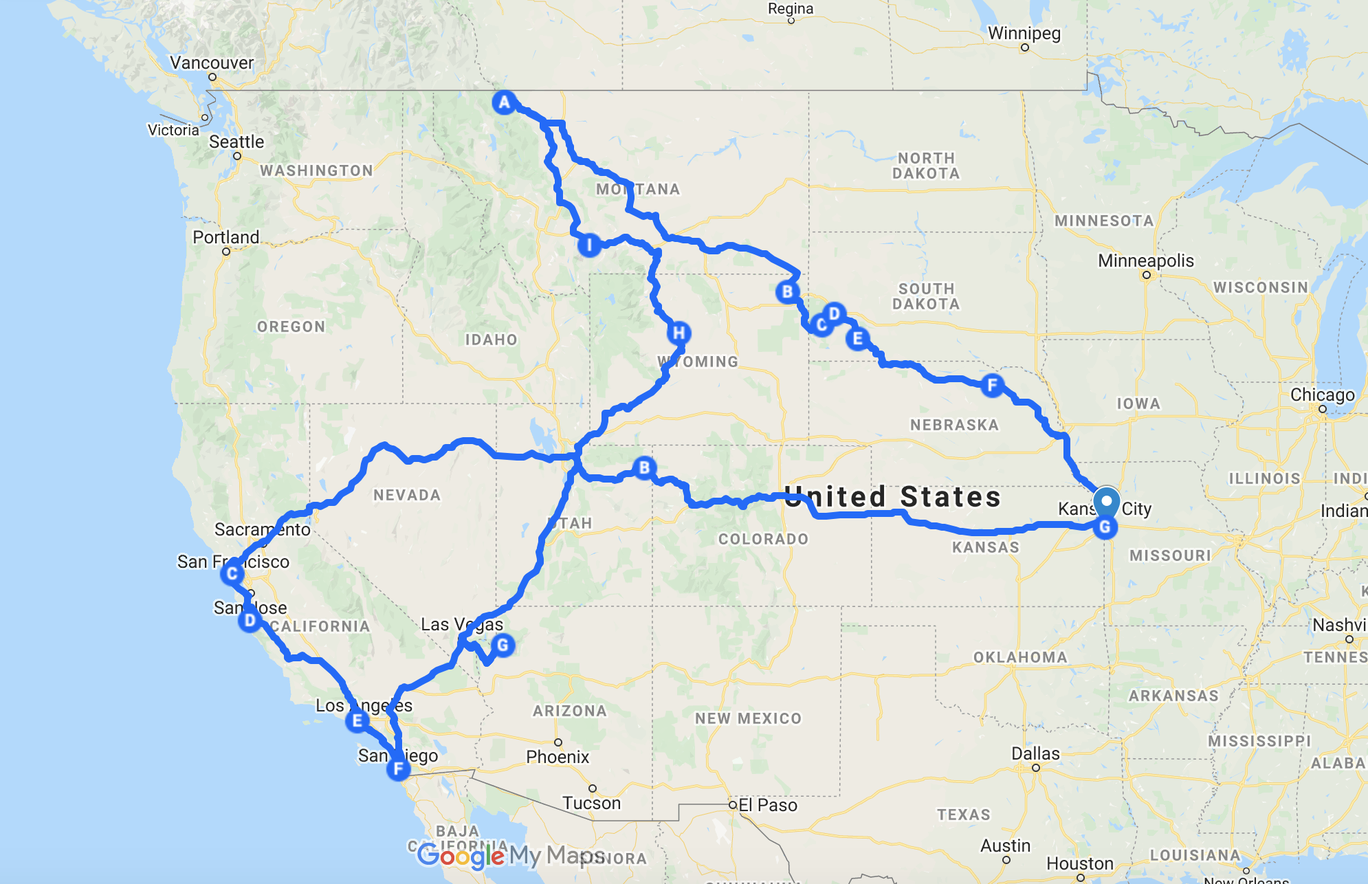
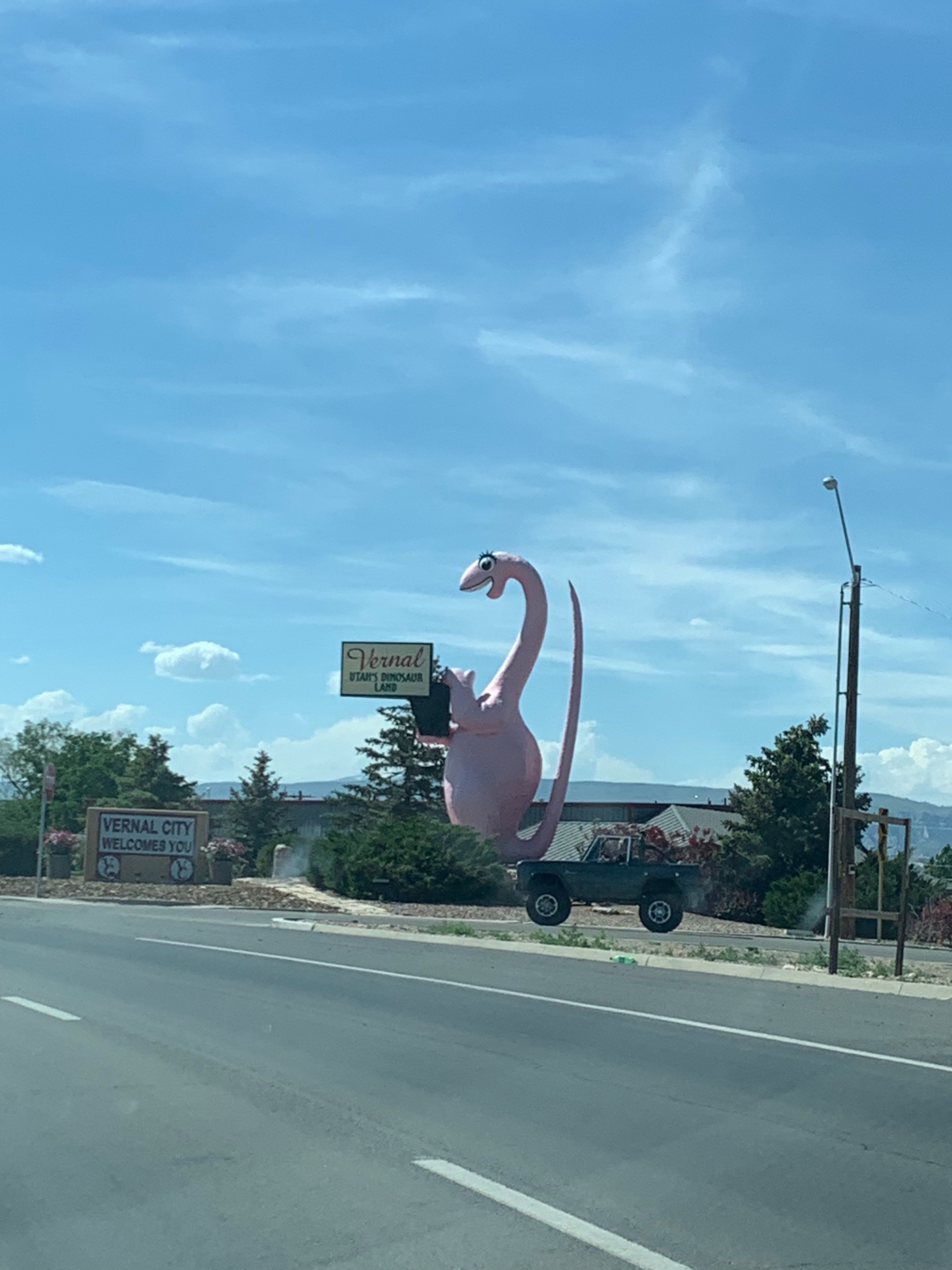
The morning after our stargazing, my Dad and I packed up our belongings and took our places in the Mazda for the 170 mile drive west to Salt Lake City. I was feeling exceptionally better after the visit to the Vernal Urgent Care the day before, the medicines they’d prescribed turned out to do the trick of minimizing my sneezing from a rate of one sneeze a minute to more like one sneeze every thirty minutes. Still, as we left the dusty streets of Vernal, I couldn’t help but feel like we were moving out into a place that’d be even more unfamiliar to me.

The Salt Lake Valley isn’t the biggest metropolitan area between the Rockies and the Sierras, that’d be Phoenix, but it certainly holds its own weight as a major cultural and economic center for the region. The gravitational pull of Salt Lake could be felt throughout our time in Utah, it is to the Beehive State what New York City is to the Empire State, though I admit I never heard any Utahns call it “the City” like New Yorkers tend to do. We made our way west along US-40 across the Uinta Basin out of Vernal towards the Uintah and Ouray Reservation, home to the Northern Ute, and the Wasatch Range beyond.

The landscape remained very dry, brownish in color, and was marked by scrub bushes and other smaller foliage, sparsely placed to use as little water as possible in such a dry place. The American West is in the middle of what’s been called a megadrought, meaning that water levels throughout that half of the continent are well below where they normally should be, and have been for years now. While there weren’t signs nexts to the sinks in our hotel rooms advising us to use less water like I’ve seen before in California, the low water levels in some of the reservoirs that we passed were worrying signs of the impacts that the changing climate has already had on life in that region.

As we made our way further west, the landscape began to become mountainous again. Unlike the Front Range on the outskirts of Denver and Colorado Springs, the Wasatch Range that splits the great population centers of the Salt Lake Valley with the rural landscape of the Uinta Basin to the east pose a tremendous barrier to travel and development. I knew that Salt Lake sat in a valley between two mountain ranges, but was totally unprepared for the extreme difference in altitude that we ended up experiencing as we drove into Park City and closer towards Parleys Canyon, the pass through which I-80 enters the Salt Lake Valley.

Salt Lake City

The first I think I’d ever heard about Salt Lake, or Utah in general, was as a young Bulls fan in the late 1990s when the Utah Jazz were frequent NBA Finals rivals of my hometown team. Later, in 2002, I got to see a lot more of Salt Lake and Utah during the Winter Olympics that were held in that city, but beyond sport I frankly didn’t know nearly as much about the Beehive State as I did about its eastern neighbor Colorado. In more recent memory, Real Salt Lake, Utah’s MLS team, has been a consistent rival for Sporting Kansas City, even playing against Sporting in the MLS Cup back in 2013, and when Kansas City’s women’s soccer team’s ownership group fell apart in 2017, the NWSL moved the franchise out to Utah where they became the Utah Royals. Only this year, 2021, did that franchise get moved back to Kansas City following ownership issues in Salt Lake.

Knowing about the region’s sporting credits may provide one sense of local awareness, but in any city it can never provide the full picture. Salt Lake however isn’t any regular city. As the home of the the Church of Jesus Christ of Latter-day Saints (the LDS or Mormon Church), Salt Lake is also tremendously important within that world, something I was keenly aware of as we arrived in that valley and first caught sight of the skyscrapers of its downtown core, soaring high above the Mormons’ holiest spot, Temple Square.

I’d booked us into a brand new Courtyard hotel in the suburb of Cottonwood Heights to the southeast of downtown. While the Vernal hotel turned out to be a step nicer than the Denver one, this hotel was substantially nicer than either of those. Primarily built as a hotel for the ski resorts in the neighborhood, the building was practically deserted when we got there on that afternoon in early June. Unlike the far higher 14ers of the Colorado Rockies, there wasn’t any snow left atop the highest peaks of the Wasatch Range. Instead of winter sports, most people who we encountered on the trip seemed, like us, to be traveling for the sake of travel itself, to get out of the house after a year of pandemic shutdowns and quarantines.

Over the previous year, as I’d planned out the still nigh mythical Great Western Tour, I’d also found other ways of getting that travel itch taken care of, through travel shows on TV and regular videos about all sorts of things on YouTube from the parts of the country I wanted to visit. In particular, in the last few years I’ve been a frequent viewer company profile and business history videos from channels like CNBC. One of these was for the Southern California burger chain, In-n-Out, which I’d discovered had expanded beyond the Sierras into, among other cities, Salt Lake.

As funny as it sounds, one of my goals of the trip was to have at least one meal at In-n-Out, to try and redeem the chain after my admittedly poor experience having lunch at one of their San Francisco locations back in 2016. Once we’d moved our luggage into the hotel room, I suggested lunch to my Dad, noting that there was an In-n-Out only a few minutes drive from there. He agreed with the idea and we got back into the car and drove deeper into the suburban sprawl. I have to say as good as the food was, I was shocked at how affordable it all was. We’ll see how far east that chain expands in the long run, I’d be happy to have one or two here in Kansas City eventually.

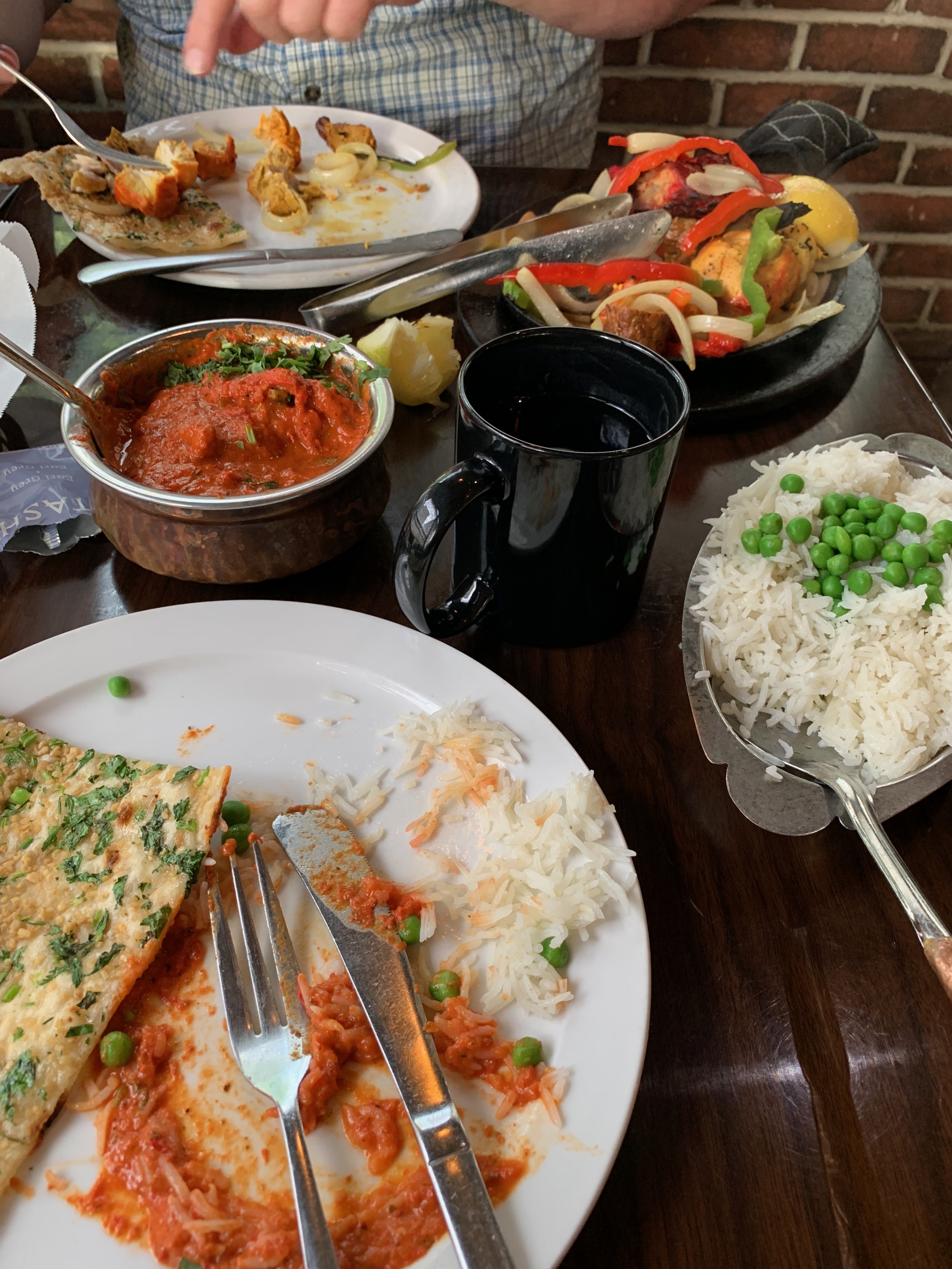
We spent most of the first afternoon in Salt Lake there in the hotel. I needed to do laundry, and we were both tired of driving. Plus, with a US men’s soccer match against Costa Rica that afternoon, I was hoping to spend at least part of the day watching the contest on ESPN. Our second big foray from the hotel that day was for dinner, which ended up taking us past two completely full restaurants before we found a Persian restaurant in a strip mall nearby, our first time trying that country’s cuisine. It turned out to be a wonderful meal, spent in a relatively quiet restaurant far from the busy tourist destinations near the ski slopes.

That evening, while I had hoped I might watch some local TV, I ended up spending most of the time reading, studying if you will, for the next day’s adventures. We’d planned on going into Downtown Salt Lake, in particular visiting Temple Square, and I didn’t feel comfortable doing so without at least some basic knowledge about Mormonism and the history of the LDS Church in Utah.

The Salt Lake Temple

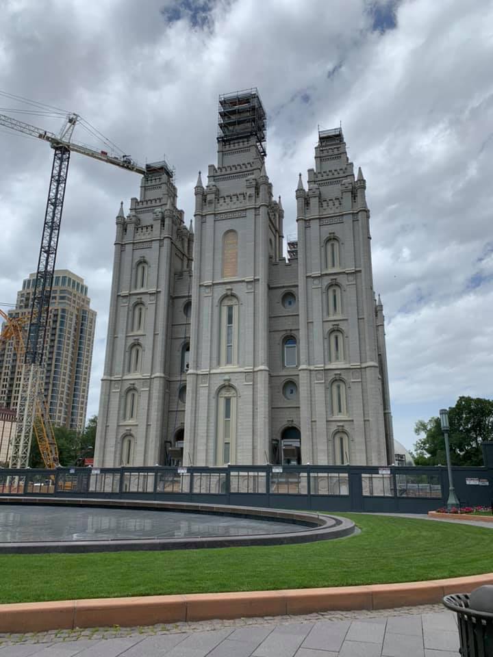
This is by no means an exhaustive study of Mormonism, or anything of the sort, but as best as I was able to make sense of it, the Latter-day Saints, as they prefer to be called, see their church as the fulfillment of Christianity through the aid of modern prophets in a tradition begun in the early nineteenth century Great Awakening with Joseph Smith (1805–1844), their founder. The LDS often found the communities where they settled in the East and Midwest to be unwelcoming to them, the Governor of Missouri even called up the militia to drive the LDS from the state. As a result, they continued westward until arriving in the Salt Lake Valley under the leadership of Smith’s successor, Brigham Young (1801–1877). This has led to Utah in general but Salt Lake in particular having a very distinct culture compared to the rest of the West, with the region around I-15 in and surrounding Utah being frequently called the Mormon Corridor.

Coming from a Catholic background, the best analogy I could think of for understanding the significance of the Salt Lake Temple and Temple Square surrounding it is the Vatican, as it is both the spiritual and administrative heart of their church, and more generally their world. There’s an old idea, one which I actually study, that American things are somehow more juvenile than Old World things. You can hear it in Churchill’s famous “We shall fight them on the beaches” speech, with the “New World coming to the rescue of the Old.” I think at its core, the fact that our societies as they exist today in the Americas are quite new settler colonial societies does feed into this idea, but by extension it’s meant that American things, New World things, often have been looked down upon in a Eurocentric perspective.

As a Catholic, a member of a very Old World form of Christianity, this is certainly something that makes sense in considering some of the reasons why Mormonism has been so badly looked down upon in general by the rest of society in the United States. That said, Christianity in this country is a complicated mix of old world churches, Catholicism, Lutheranism, and Orthodoxy in particular (immigrant churches) standing alongside those Protestant churches, the Episcopalians, the Methodists, the UCC, the Baptists, and the AME Church, that have roots in Europe, largely in Britain, but have been so thoroughly Americanized in the centuries since independence as to be equally foreign to their European counterparts. In this mix stands the Church of Jesus Christ of Latter-day Saints, a church born in the United States that grew up on the frontier of American society, a community that’s always been a bit of an odd one out alongside its peers.

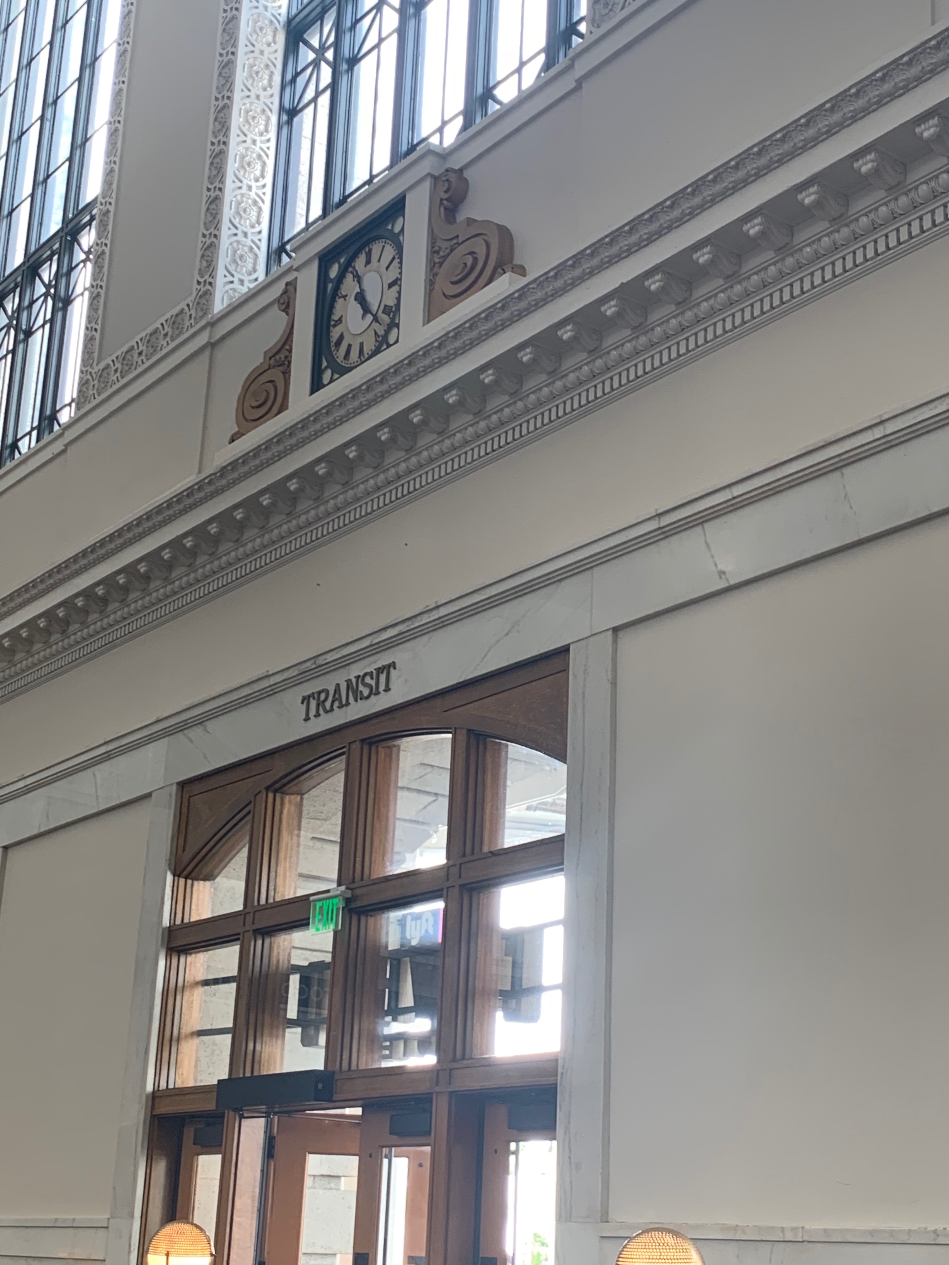
We drove into Downtown Salt Lake, and after finding parking, made our way up to Temple Square. Unfortunately, the complex was under extensive seismic renovations to ensure the buildings’ stability up to a 7.3 earthquake on the Richter scale. Nevertheless, we were able to walk around the outside of the complex and find an open footpath leading to the courtyard in front of the Temple, where we were able to stop and look at the building up close. Purported to be based in design after Solomon’s Temple in Jerusalem, it’s an impressive building, clad in quartz monzonite, its spires seem to represent the permanence of the LDS in Utah. Near the Temple stands another building of immense significance in the history of silent film, the old Hotel Utah, now the Joseph Smith Memorial Building, where in late 1920 Charlie Chaplin completed cutting his classic film The Kid. He had to smuggle the reels out of California where his first wife was demanding them as her property in their divorce trial.

From Temple Square we returned to the car and left the Salt Lake Valley for the Utah Olympic Center high up in the Wasatch Range over Park City. The center, home to a number of ski slopes, as well as a few ski jumps that lead in the summer months into a swimming pool well placed on the edge of a cliff, hosts two museums in its visitors center. On the lower level is a museum dedicated to skiing in Utah, while the upper level hosts a nostalgia-trip of a museum holding relics of the 2002 Winter Olympics. While I enjoyed seeing the ski stuff on the lower level, not being a skier myself I found it less engaging than the Olympic memorabilia on the upper level.

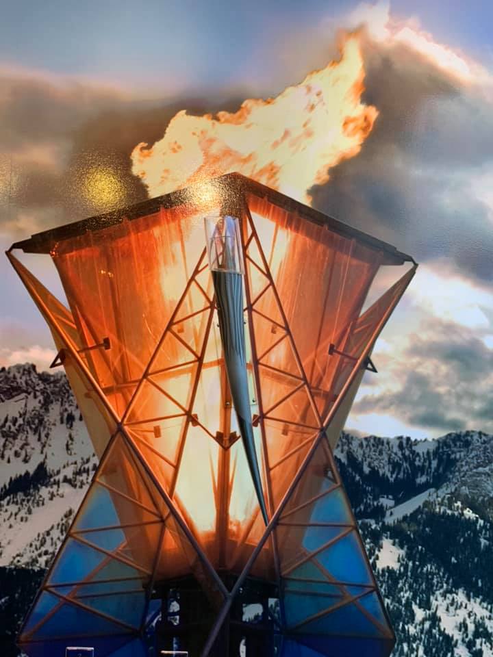
The Salt Lake Olympics were the first winter games I can remember watching nearly in full. There was something about them being in the US, even if they were over a thousand miles away in a state I’d at that time never been to, that made those games feel like they were on my own home turf. It was especially interesting to me seeing how the uniforms and sportswear has changed over the years, how the speed skaters’ garb has become even more aerodynamic, allowing for today’s skaters to beat the records of 20 years ago time and again, or how much the US hockey sweaters haven’t changed all that much, the same old trusty look for the same old team that as long as I’ve been watching can beat the Russians but always seems to come up short against the Canadians. Ugh, Canada.

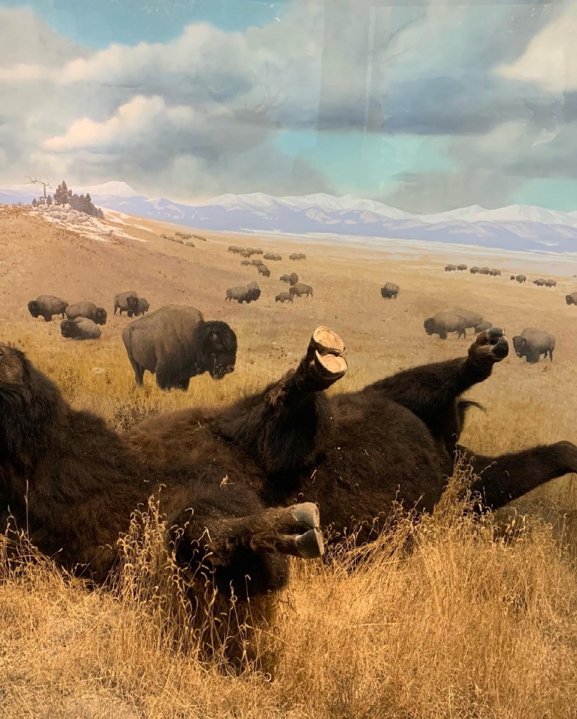
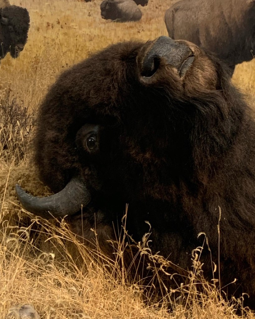
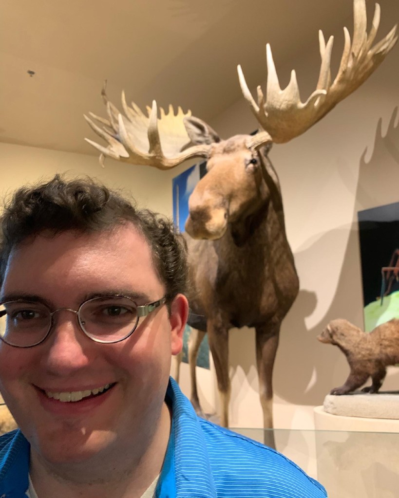
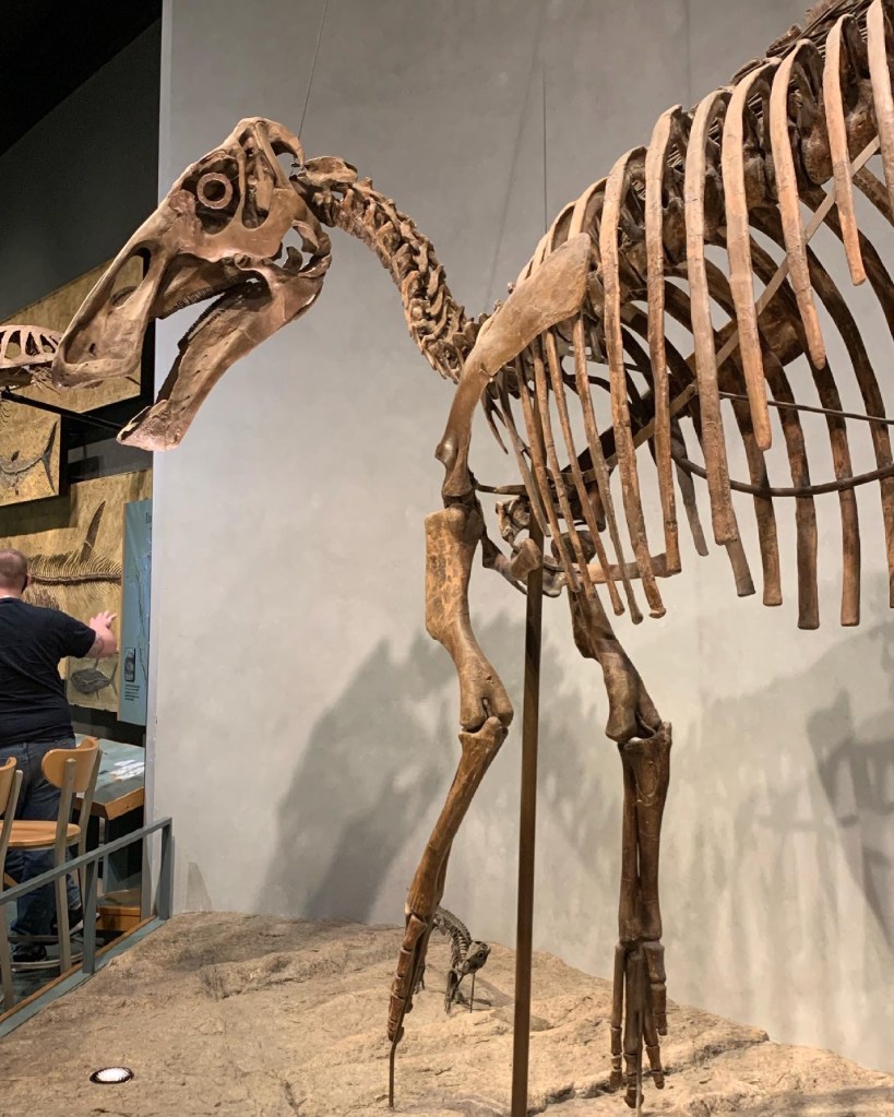
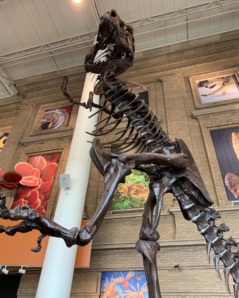
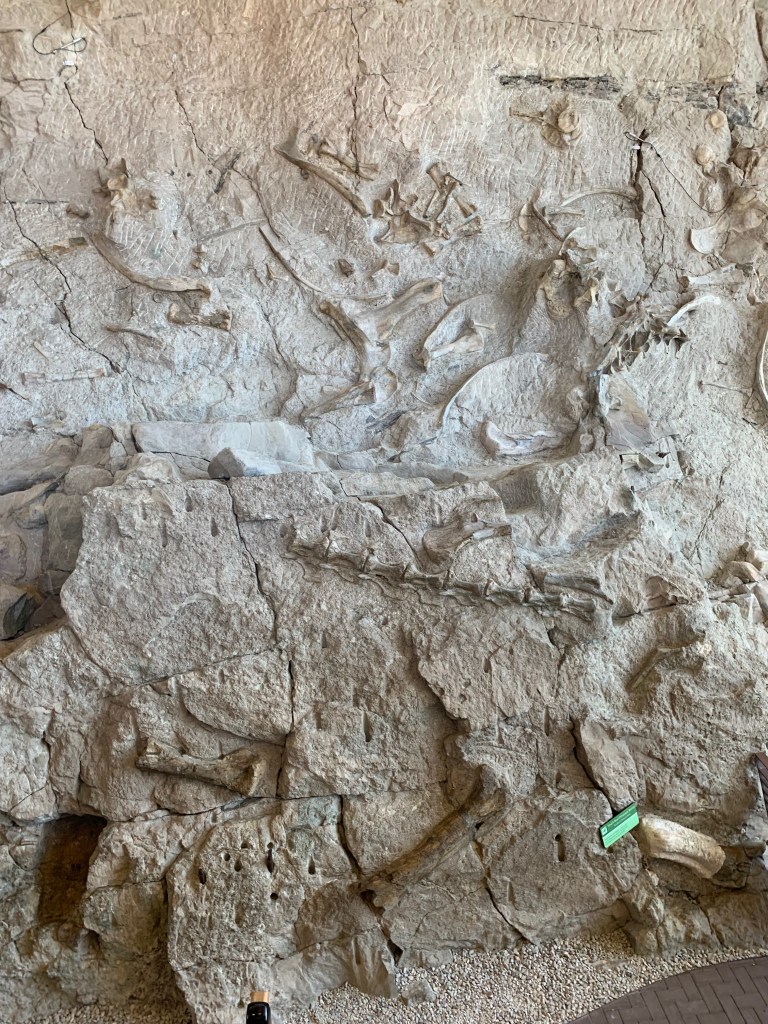
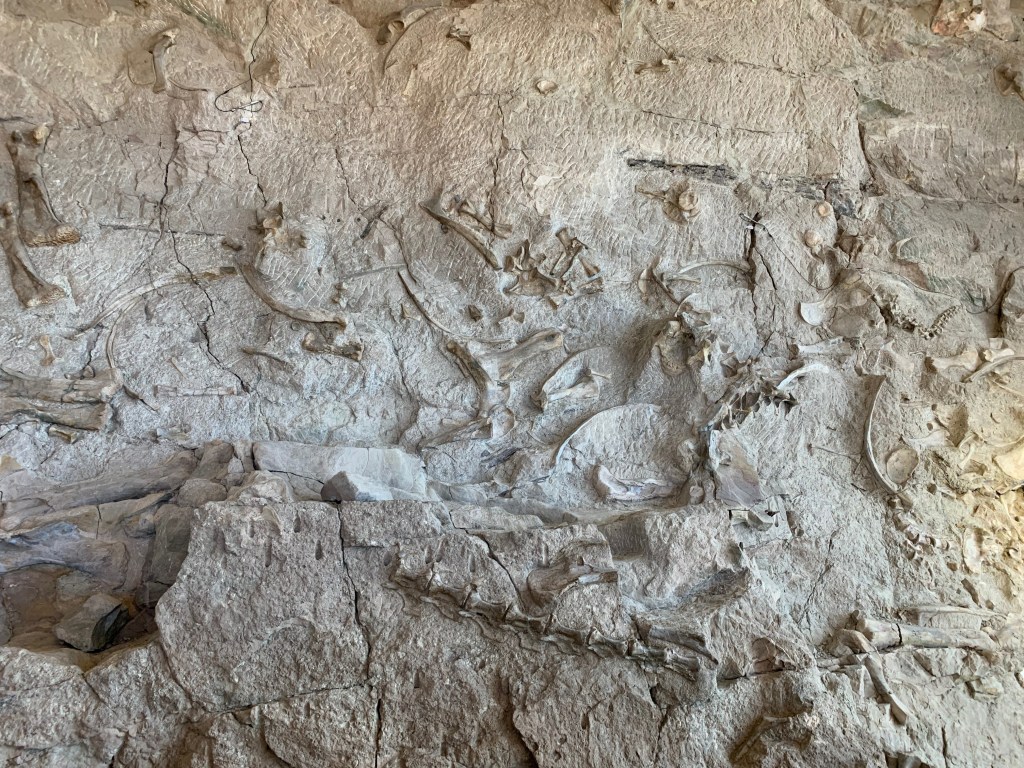
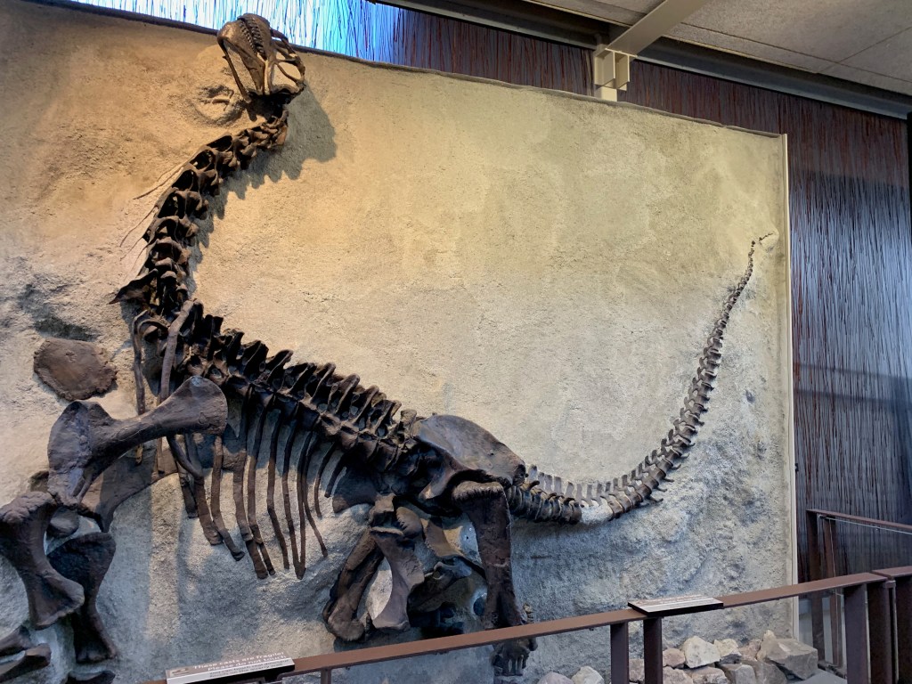
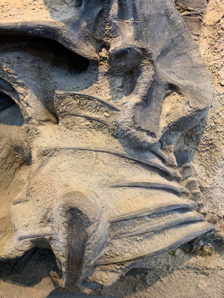
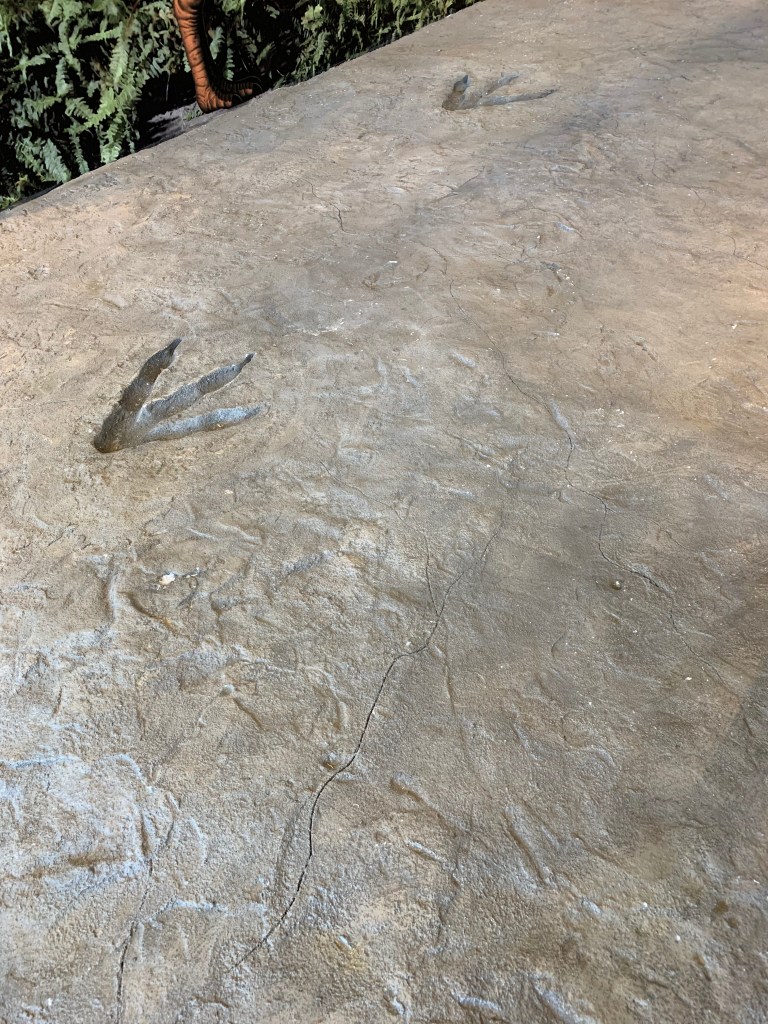
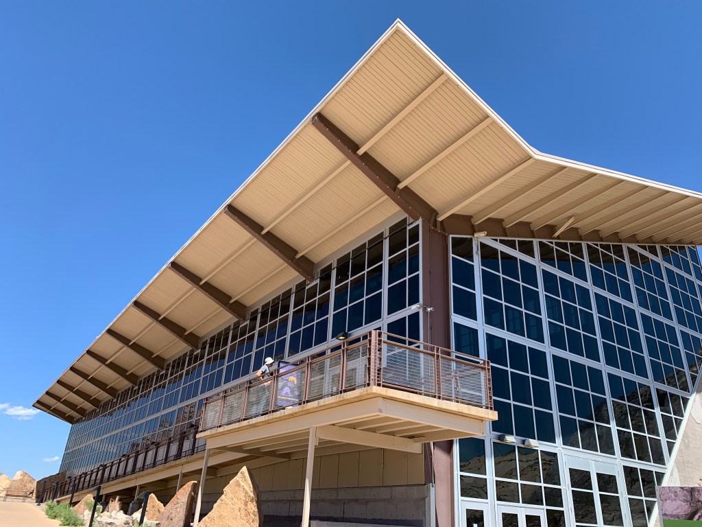
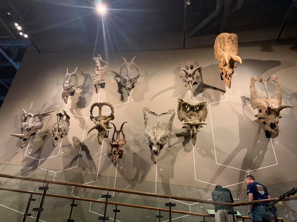
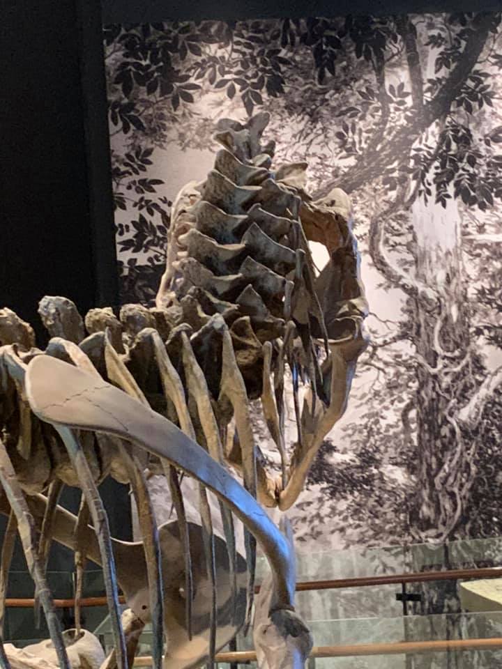
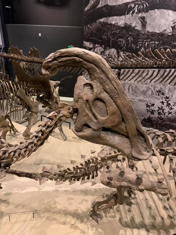
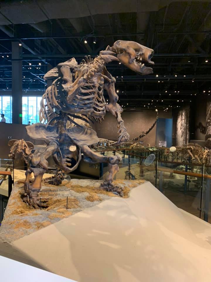
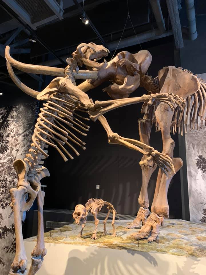
From the Olympic Center we returned to the Salt Lake Valley and drove to the campus of the University of Utah, where we made a stop at the Natural History Museum of Utah in the 10 year old Rio Tinto Center. Of the natural history museums I’ve visited here in the US, this one in Salt Lake has proved to be the most forward thinking in the way they display their exhibits, owing in large part to the youth of their building. The building itself reminded me a bit of the newer sections of the Royal Ontario Museum in Toronto, which opened to the public in 2007. In terms of the exhibits themselves, I was especially impressed by how regional in focus they were. Sure, you had your dinosaur highlights, your Tyrannosaurus Rex and your Triceratops, but so many of the fossils on display were less famous dinosaurs that were quarried in Utah, itself one of the great fossil states. On top of this, the museum dedicated an entire floor of exhibit space to Utah’s native peoples, the Shoshone, the Goshute, the Ute, the Paiute, and the Navajo.

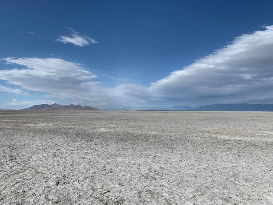
Leaving the museum, on my Mom’s suggestion, we drove west across the valley to the Great Salt Lake itself. She told us there was a Great Salt Lake Visitors’ Center that we could stop at that’d tell us more about the lake itself, and after a drive we came to a building that looked like it might be a visitors’ center. As it turned out, we’d stopped at the Saltair concert venue, a little ways to the east of the visitors’ center, but while parked there, we left the car and walked a half-mile out onto the dried lake bed until we reached the salty water. I was surprised at the strong smell of the salt lake, which frankly wasn’t something I should’ve been surprised by, after all it is a salt lake, and should smell of salt. From the water we walked back to the Mazda and made our way westward along lakefront, figuring we’d run into a visitors’ center eventually, that or we’d start rounding the lake. Once we did find the visitors’ center, we were surprised to find how close we’d actually gotten to it on foot.

The dried up bed of the Great Salt Lake

By that point, sunset was coming fast, and we decided to head back to the hotel and figure out the next day’s drive from Salt Lake to Grand Junction. As tough as the last two longer drives had been, no matter which route we took on this one it’d be harder than anything else we’d done yet. By interstate, Salt Lake and Grand Junction are connected by I-15 and I-70. This involves a 110 mile stretch of I-70 in south-central Utah without any services, and while the Mazda can usually travel around 300 to 320 miles on a tank of gas, the idea of driving so far without places to stop or people who could help should we break down gave us pause. The other route was I-15 to Provo and then US-6 diagonally southeast toward Green River, Utah. This route would be quicker, and go through more towns with gas stations and other services, but it involved a 120 stretch of winding mountain highway that has been called one of the most dangerous in the United States. Naturally then, we chose the second route.

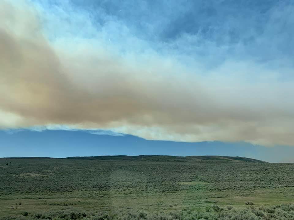
All things were going well for the first part of the drive until we left I-15 in Provo and made our way into the mountains on US-6. It was as we were passing through Spanish Fork, a pass in the Wasatch Range, that we began to see the emergency UTDOT signs warning that US-6 was closed ahead due to a wildfire. The megadrought was a big part of the cause, as was a lightning strike more particularly. I suggested we turn around and head back to I-15, take the long way around on the interstate and trust that we’d have the foresight to not run out of fuel in that 110 stretch of highway without services. Dad, who was driving, decided to keep going ahead, and soon we made it to the detour around the fire, which took us and countless semis, RVs, and other vacationers onto a winding backroad that was hardly wider than a cowpath. This continued for a good eight miles, until we came to a backup just beneath the place where the fire itself was burning on the mountainside. We waited for a good 20 minutes as the northbound traffic cleared, before we continued on our way out of harm’s way and toward I-70.

The Bear Fire

The Deserts and the Plateaus

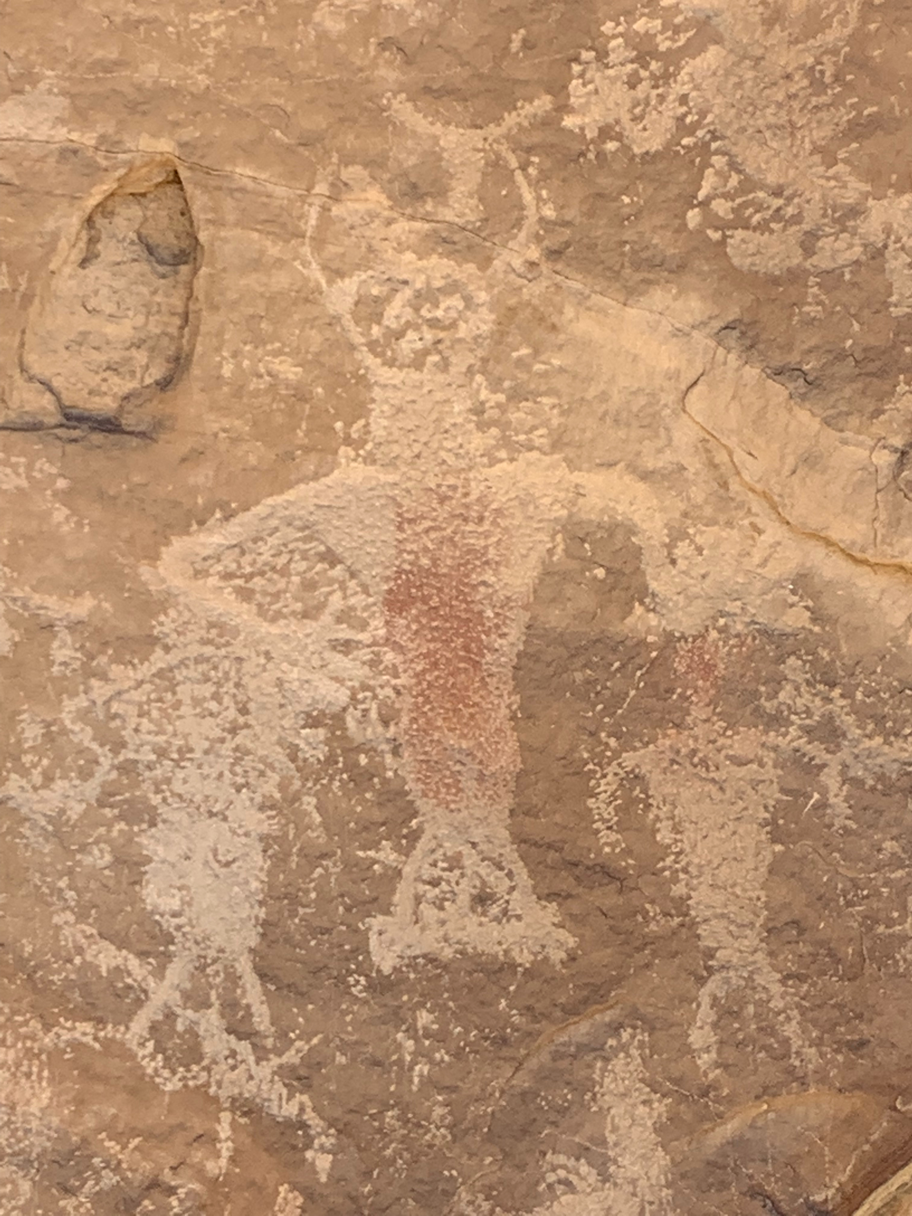
While we’d spent a fair amount of time in the high deserts around Vernal, that didn’t compare to the far harsher deserts around the Utah crossroads town of Green River. Situated on I-70 at the intersection with US-6 and US-191, Green River seems a bit of a misnomer for a town in such a dry place as this. And yet, through it flows the Green River itself, the great lifeblood of eastern Utah, over whose banks further upstream we’d spent an evening stargazing in Dinosaur National Monument just earlier that week.

Typically in a river system, the longer river will bear the more prominent name. This is why we usually talk about the Mississippi River Basin rather than the Ohio or Arkansas River Basin, or why the Green River is usually seen as a tributary of the Colorado River which flows from the Colorado Rockies down through the deserts and canyons of the Intermountain West until what’s left of it after thousands of miles of dams and agriculture trickles into the Gulf of California on the eastern side of the Baja California peninsula. That said, hydrologically the Green River is longer than the Colorado River, it just happens that because of some politicking by an early 20th century congressman from Colorado’s western slope that the then named Grand River was renamed the Colorado River and recognized as the main river of that drainage basin. Naturally the congressional delegations from Utah and Wyoming objected.

The desert in Utah

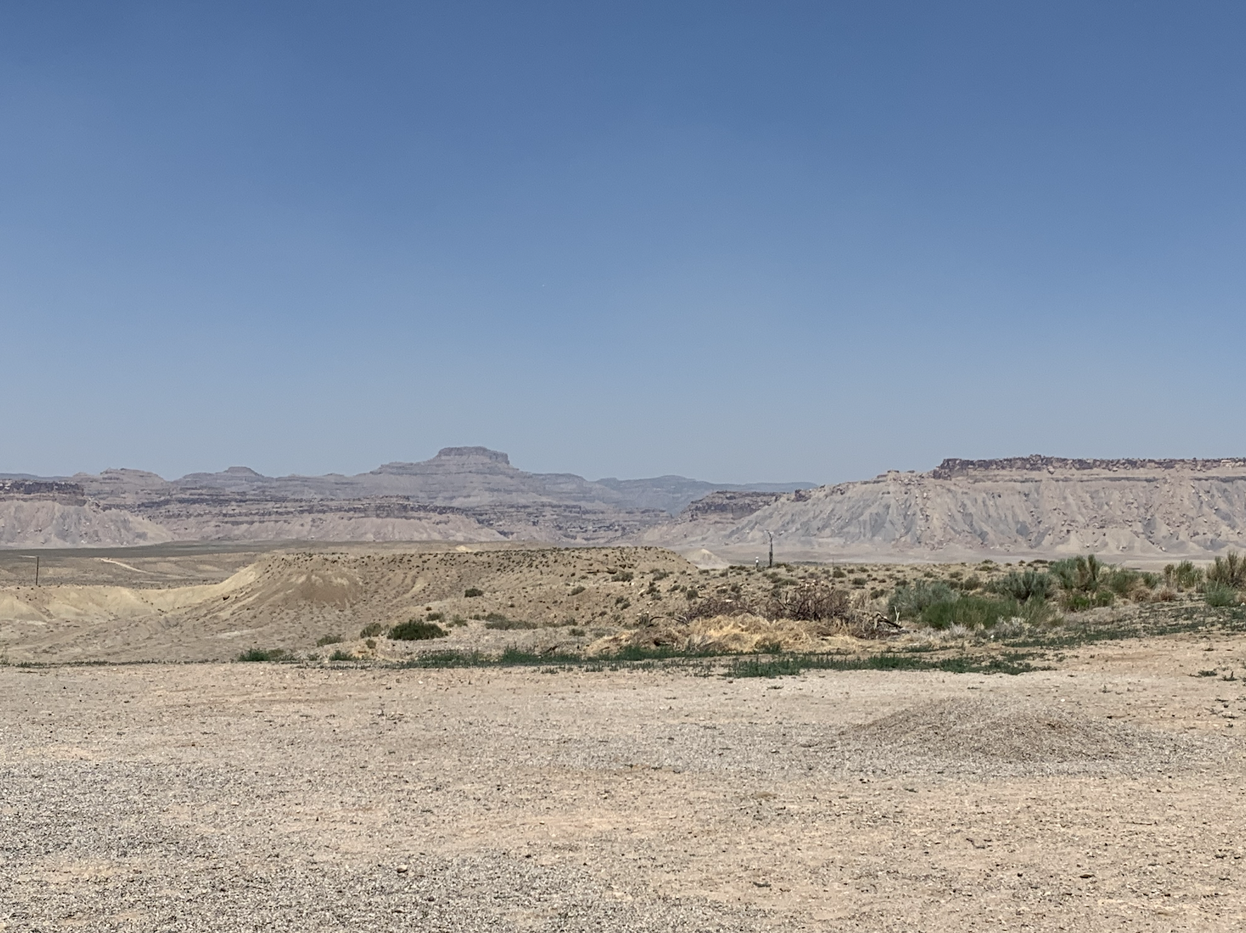
As we drove along I-70 across Utah, the landscape changed from a scene of brown soil and low shrubs to one of yellowish white sandy ground, with little to no greenery around, the desert as one might romantically imagine it. We stopped after a while at a rest area at the top of a hill, and took a few minutes to experience the environment, the atmosphere of this most alien of settings for us. Coming from the Midwest, the usual color palette that nature provides us is filled with greens and brightly colored flowers. Kansas City is a metropolis set on the prairie but filled with trees. In contrast to this, the desert we now crossed seemed harsh to our eyes, yet at the same time there was an element of beauty to it all the same.

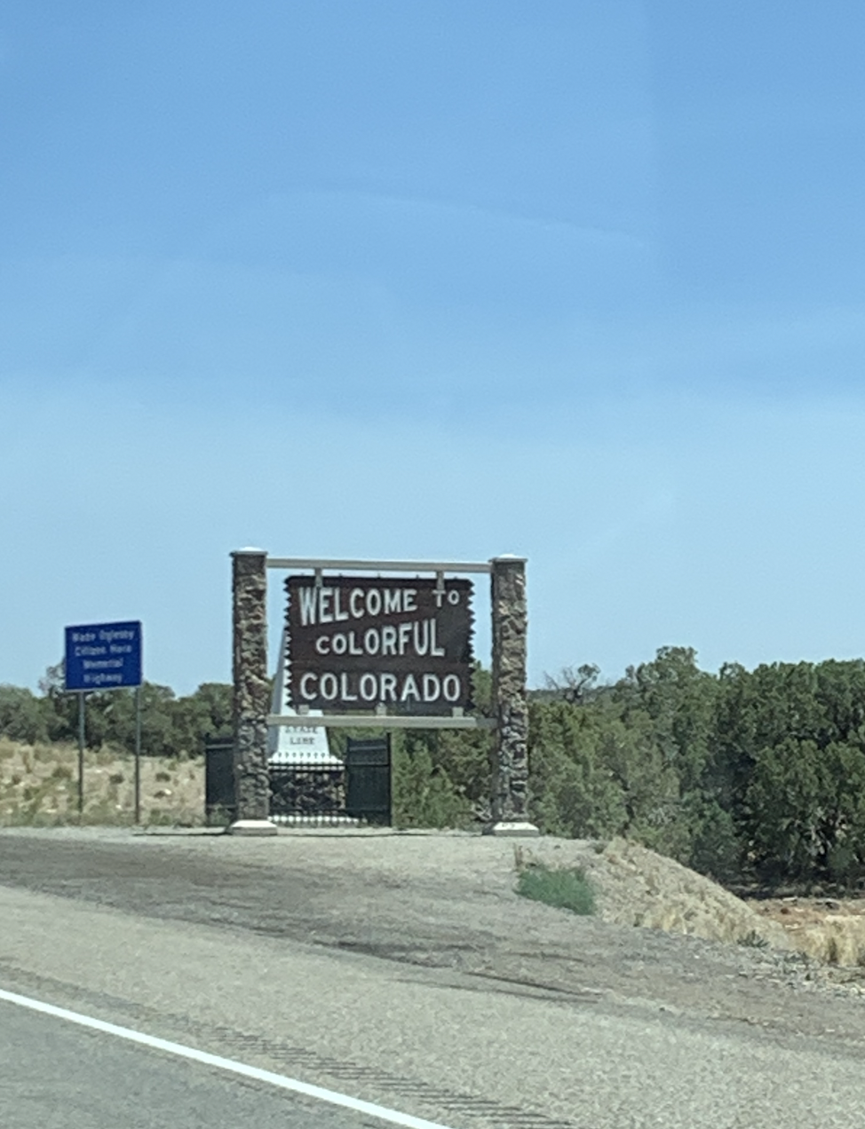
With a higher speed limit of 80 mph, we quickly made our way across Utah and back into Colorado, the Welcome to Colorful Colorado sign a welcome sight and a reminder of what one might call familiar ground closer to home. We were still west of the Rockies, in a part of the state that neither of us knew terribly well; still a good four hours drive away from the familiar confines of metropolitan Denver. The Colorado border quickly brought our next stop onto the horizon, Colorado National Monument.

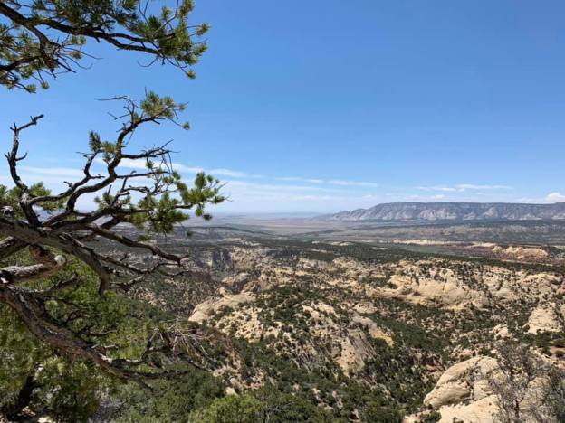
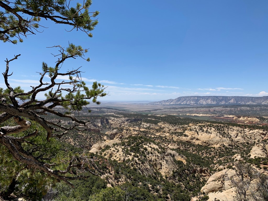
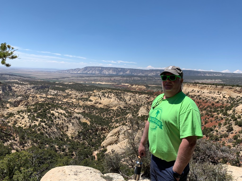
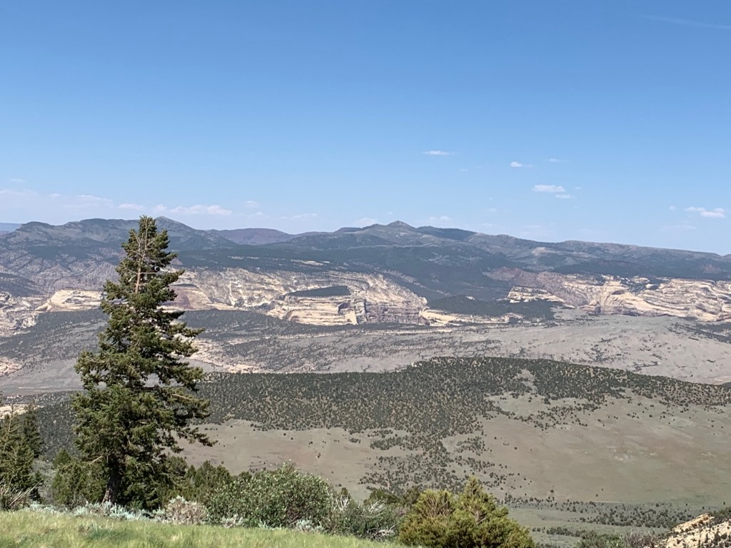
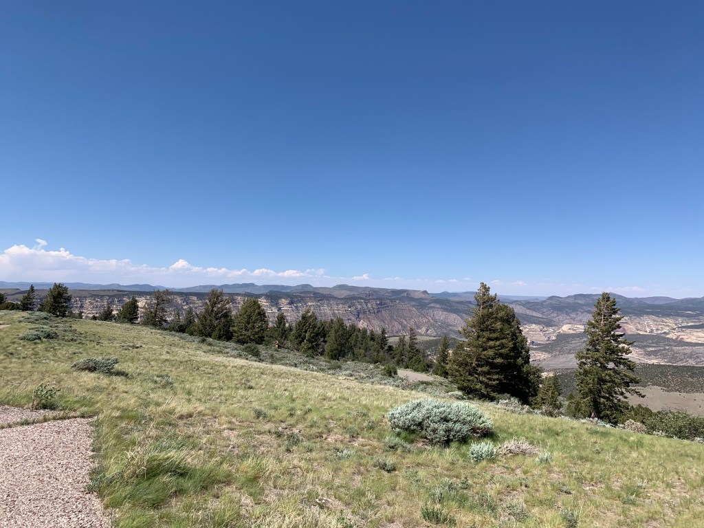
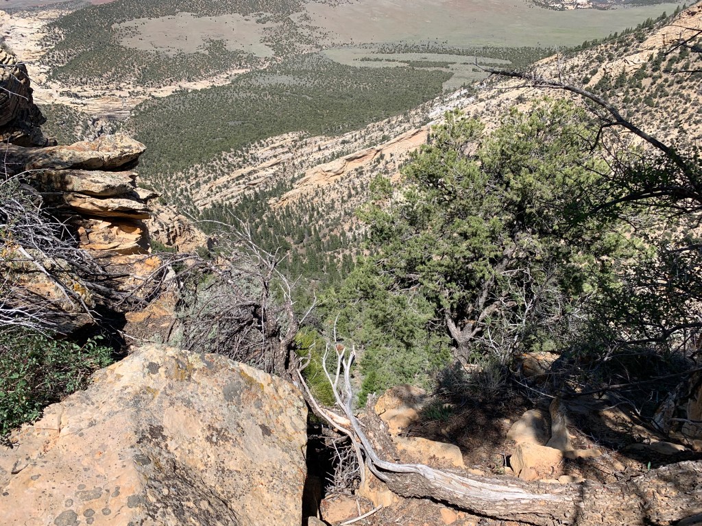
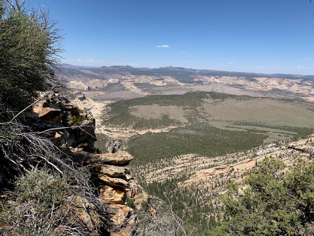
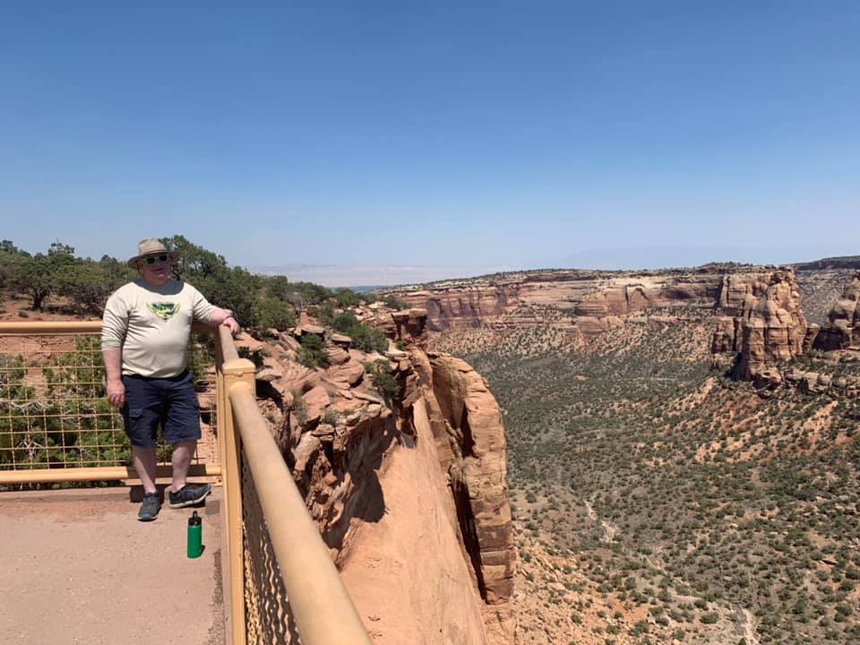
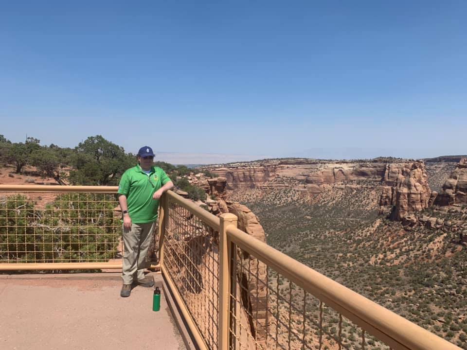
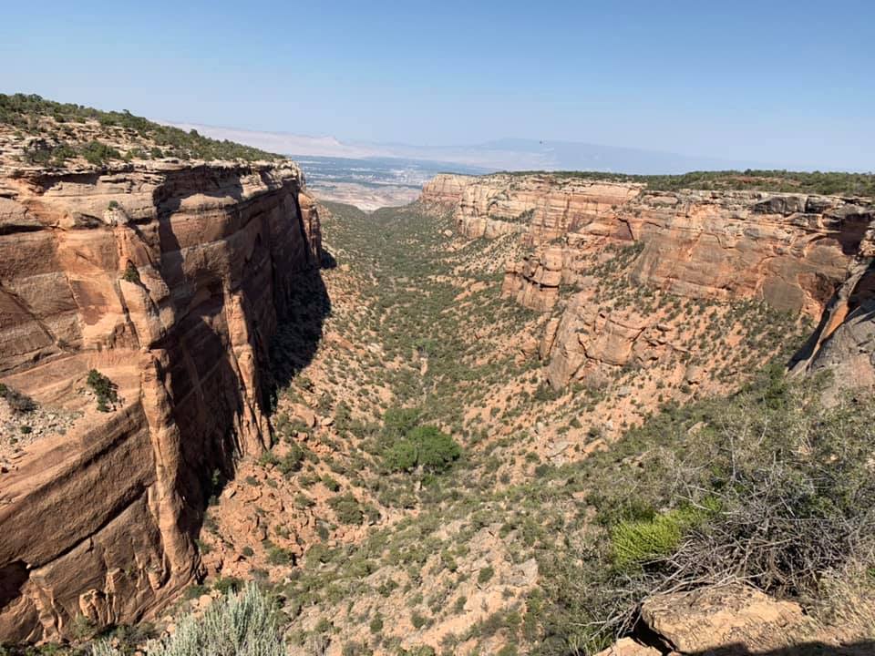
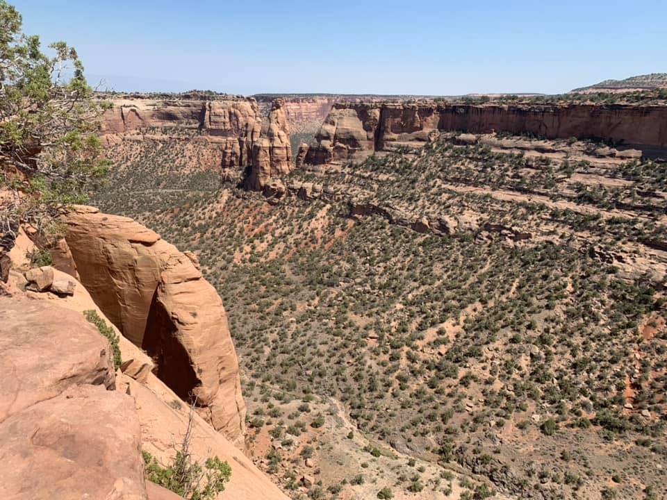
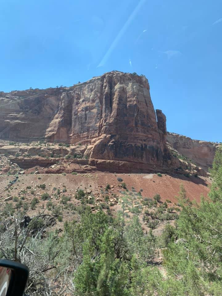
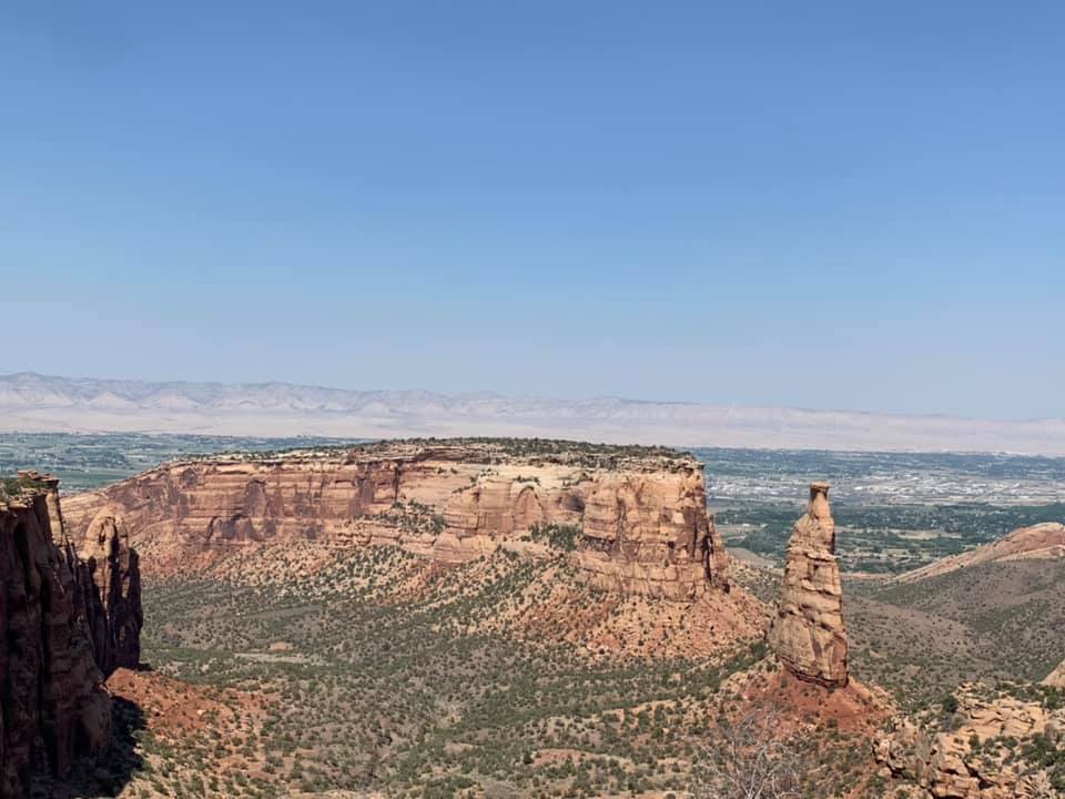
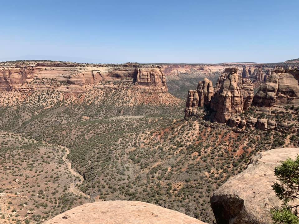
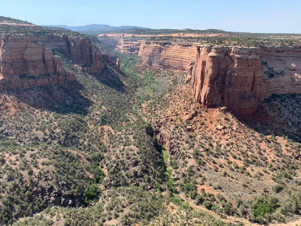
A series of canyons, buttes, and mesas to the south of Grand Junction, Colorado National Monument is quite easily the most impressive natural site we visited on this trip. Established as a national monument by President Taft in 1911, the main road leading through it, the aptly named Rimrock Road, was carved into the landscape in the 1930s as a New Deal project. That 24 mile stretch of pavement proves to be one of the most scenic of scenic routes we could’ve ever taken to get to a hotel, and well worth the extra night on the drive east. The views reminded me of the prologue scene from Indiana Jones and the Last Crusade, or any number of other movies or shows set at the turn of the last century, when the West was just beginning to be incorporated into the tourist’s America.

At the monument’s main visitors’ center we stopped and went for a mile hike out on the cliff edge, stopping at various points to look over the precipice at the deep canyon below. Years ago, my parents had bought a photo print of Colorado National Monument with the mesas to the north behind Grand Junction. That image had been up on the wall for most of my life, first in their house in Wheaton, then on the farm in Kansas City, KS, and now in their current house in Kansas City, MO. Only recently had it come down for whatever reason, yet as we made our way through that monument, we kept looking for that view that was in the picture. Surely it’d be out there somewhere. Whether we found it or not remains to be seen, but certainly of the places we’ve visited on this trip, Colorado National Monument will be one that we’ll return to.

The High Rockies

We considered going back up the switchbacks into the monument that evening to give the stargazing a second go, but ultimately decided against it, instead choosing to go find dinner. The next morning came quickly, and after some time watching the Saturday morning shows on CBS, we returned to I-70 and continued the journey eastward back into the Rockies. Denver is nominally only about 4.5 hours east of Grand Junction, but for drivers like us who are less used to that sort of terrain, we ended up taking far longer to get to that evening’s destination. It wasn’t for any poor traffic or poor navigating on our part, but rather for the fact that we had one last day left on the trip and wanted to use it as best we could.

I’d been thinking for a while that a neat way to cap this particular western tour would be a drive up to the top of Mt. Evans, whose summit boasts the highest paved road in the United States at 14,271 ft (4350 m). We’d driven up it once before in 2005, arriving at the summit in the middle of an afternoon thunderstorm, but hadn’t made a return visit since. That said, when I looked at road conditions that morning, I found that entry passes to the road had been fully booked for the day, and so spent the first two hours of the drive trying to come up with another detour, one that would provide the adventure we were looking for.

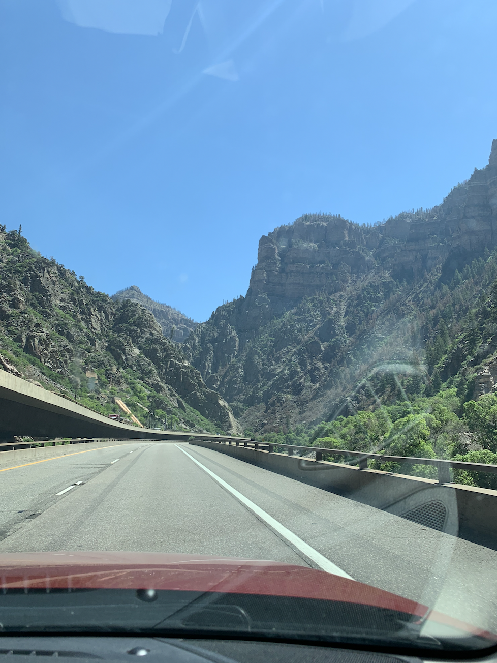
Leaving the deserts of the western slope, we soon entered the narrow winding course of the Glenwood Canyon, aptly called one of the crown jewels of the Interstate Highway System. At the heart of the canyon is the Colorado River, flowing swiftly westward over rapids frequented by whitewater rafters. I-70 was built then to the north of the river, with a walking/cycling trail between the eastbound lanes of the highway and the river’s roaring current. At certain points when the canyon reaches its narrowest, the westbound lanes rise above the eastbound lanes along the canyon wall, proving just how difficult it was to extend the interstate this far into the Rockies.

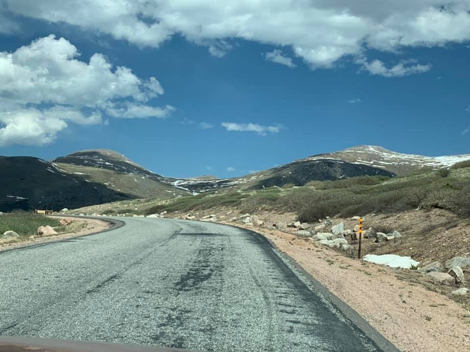
After the Glenwood Canyon, the road rises up to crest the Vail Pass at 10,666 ft (3251 m). While I haven’t gotten terrible altitude sickness for a long time, driving up this pass was one moment when I did seriously consider it on the trip. We stopped at a rest area at the top, alongside countless other travelers, most of whom wanted to take in the sights at such a high altitude, let alone of the remaining snowpack on the tops of the nearby fourteeners. While standing around there in the Sun looking at a paper map of the state given to me at the Colorado Welcome Center in Burlington a week before, I tried to find some scenic routes we could take east in to Denver that would be just long enough to give us something neat to see and do besides just drive on I-70, but not too long as to wear us out before the 8 hour drive the following day across Kansas.

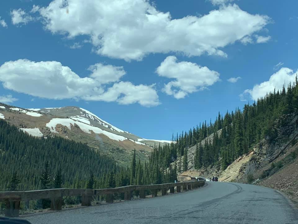
Eventually, we decided to leave I-70 at Frisco, and head south on CO-9 through Breckinridge before continuing over the Hoosier Pass into Park County. From there, we drove to US-285, turning east towards Denver in the high altitude yet wide open South Park Valley around Fairplay. We stayed on US-285 until the small crossroads of Grant, where we turned north on a small narrow road that led us along a series of creeks and streams up to the Guanella Pass (11,669 ft / 3557 m) over the crest of a range just to the west of Mount Evans and down another series of switchbacks towards the old silver mining settlement of Georgetown, which lies along I-70’s path.

The drive from Grant to Georgetown proved to be well worth the 2 hour detour. The views were breathtaking to the nth degree, the road, which was well traveled by many others who like us were getting away from the business of the interstate and the cities, seemed to be an attraction in itself. Along the way we saw the majority of the wildlife we’d seen on the trip, a number of herds of bighorn sheep who spent their days grazing the high mountain grasses along the road. Our descent into Georgetown was marked by the long line of cars and the equally pungent smell of their brakes as our vehicles descended from the pass into that town.

From Georgetown we made our way back into Denver, through the metropolis and out to our last overnight stop at a hotel near Denver Airport. I figured it’d be better on our final day’s drive if we started on the east side of Denver, to avoid most of that city’s traffic, thus speeding up the journey even further. That evening we joined some friends for dinner near the hotel, before a quick night’s sleep.

The following morning, as we awoke to prepare to make the 600 mile drive east to Kansas City, I kept thinking about how different the landscapes we’d been in were from one another. On Friday we’d driven across different shades of desert, on Saturday through the high Rockies, and now on Sunday we’d be crossing the Great Plains, an entirely different shade of golden brown compared to what we saw in the high deserts of Utah and Colorado. As we sped east on I-70, I kept my eyes on the side-mirror next to my seat, looking out first as the hazy mountains receded over the horizon and later as the high clouds that surrounded their tallest peaks slowly began to recede as we moved eastward around the curve of the Earth. To my amazement, I only lost sight of those clouds rising high over the Rockies once we were 40 miles into Kansas just past the town of Brewster.

Conclusion

This has been a wonderful trip, something I’d hoped to do for a long time. As an adult, I’ve been able to experience many of the things I saw as a child over again, visiting cities like Denver and driving through the Rockies, that I’d done so often on summer vacations. Yet now as an adult, I’m able to appreciate these sights far better than before, and to marvel at how wonderful it is that I’ve been able to visit them. While there were still things I wanted to do that we didn’t get to do on this trip, and while I’m left wondering what more I could see and do in the Mountain West, all of this leaves me with a sense of excitement at what the future could hold.

My greatest hope is that that future will prove to be just as pleasant an experience as this week on the road was. In total, we drove 2,652 miles (4268 km) over 8 days. At its western end, this trip took us within a day’s drive of all of the major American cities on the Pacific coast, while throughout we never really strayed too far from either of the major cities we visited, Denver and Salt Lake. It’s amazing to me that we could really be so close to both and yet in so remote of places throughout the week. As Midwestern as Kansas City is, its relative isolation to its neighboring cities, the closest Omaha and St. Louis are 3 and 4 hours away by car respectively, provide this city with a closer experience to its western counterparts than to those in the East, certainly in the Northeast.

Sneezing across the West, Part 1

Click the Instagram logo above to follow my updates of this trip as they happen.

For many years now I’ve thought about the idea of taking a big road trip across the Western United States. For a while my idea was to drive from Kansas City up to Portland, Seattle, and Vancouver, before my focus shifted southward toward trying to go to the Monterey Bay Aquarium in central California. Last spring and early summer, in the midst of the first stages of the COVID lockdown, I began to plan what would be the trip of a lifetime.

The Grand Western Tour, yet to be fully taken.

It was to be six weeks driving across the western states, beginning in Kansas City, going through Denver, then onto Salt Lake City, before crossing Nevada and driving down from the Sierras into California before finally making my triumphant arrival on the Pacific coast at the Golden Gate Bridge. From there, I was going to drive south along the Pacific Coast Highway to San Diego, before turning northeast on I-15 and heading out of California towards Las Vegas, with a detour to see the Grand Canyon, and a quick pass through Salt Lake again on the way into Wyoming.

The drive would then take me up through western Wyoming through some particularly noteworthy paleontology museums and fossil sites such as the Wyoming Dinosaur Center in Thermopolis, before entering Montana, passing through Bozeman toward Glacier National Park, the northernmost end of the route. From Glacier, I was going to turn onto the homestretch, driving southeast towards the Black Hills of South Dakota, and along US-20 in northern Nebraska with stops at the Agate Fossil Beds National Monument in northwestern Nebraska and the Ashfall Fossil Beds State Historic Park in northeastern Nebraska.

It was going to be a long drive, half of the summer, seeing as much of the American West as I could. Naturally, the plan was scaled down considerably, from a whirlwind 1.5 month odyssey to an 8 day tour of Colorado and Utah. As it turned out, my Dad was happy to join me on this trip, and has proved to be just as great a traveling companion as I remembered from our many family road trips in the Midwest and out to Colorado between the 1990s and 2010s.

We left Kansas City early on Saturday morning, 5 June, making it across the Great Plains on I-70 in Kansas and eastern Colorado without much trouble. We arrived in Denver around 16:00, making our way through the city streets to our hotel in the Capitol Hill neighborhood without too much trouble. After Chicago, Kansas City, and St. Louis, Denver is perhaps one of the cities that I’ve spent the most time in. From 1997 to 2005 my parents and I would pass through Denver on our way for a week up at a dude ranch in Pike National Forest. The Mile High City has served as a gateway to the Rockies for millions of tourists and locals alike, and it remains one of my favorite cities in this country.

While I’d hoped the trip would be a welcome break from regular life, an exciting adventure into a part of the country I’d wanted to get back to for a long while, I brought with me some of the troubles of regular mundane life, namely in a cold that was borne out of my allergies. I woke up on the morning of Wednesday, 2 June to find my throat had been dried out over that night by the ceiling fan in my bedroom in my parents’ house. I hoped the consequences wouldn’t be too bad, and certainly I’ve had worse iterations of this particular malady, but knowing it wasn’t COVID, especially considering I’ve already been vaccinated, I figured I’d be safe to travel, as long as I wore a mask whenever indoors or around other people besides my Dad. It’s meant that I’ve stuck out like a sore thumb in many of the smaller towns that we’ve stopped in for fuel and food, but for everyone’s sake, I’m fine with it. That being said, I was looking forward to seeing if the mountain air might help my sneezing go away quicker, which it could be said has worked. Nevertheless, this isn’t the most pleasant way to travel to say the least.

Denver

Denver remains one of my favorite American cities. It’s been so tightly connected to some of my favorite childhood memories, namely our annual family vacations in the Front Range, that it’s honestly one city I’d be happy to move to for work after I’ve finished my doctoral work in Binghamton. I’d trade the Appalachians for the Rockies any day. Like many of the cities and towns we’ve traveled through so far, Denver started as a frontier town, built by American settlers heading west into Colorado from the Midwestern and Northern states in the years just before the Civil War.

In some ways, it’s refreshing in an odd way to be in such a young city, yet a city that has it’s own sort of maturity. I’ve often thought that this may be how an Australian city like Melbourne feels. Even Kansas City feels a bit older than Denver. Sure, the modern City of Kansas City was founded by American settlers in 1839, but it was built near the site of an older French colonial trading post. Colorado may have its Spanish colonial heritage, but that seems to be much more strongly centered in the southern parts of that state near the border with New Mexico. The Denverites certainly have done better for themselves than we Kansas Citians have done, though that may be in part thanks to the prosperous mining economy and the immense natural beauty of the Front Range, both of which Kansas City’s own economic might and natural beauty aren’t easily or fairly comparable to.

I’d hoped to do a couple of things while we were in Denver, though my fairly constant sneezing kept our trips out of the hotel room slightly less frequent than I’d have hoped. That said, on the first night we were there we did go to an Indian restaurant on 6th Avenue, called Little India, which was a good remedy for my condition. I don’t have much of a toleration for spices of any sort, as many people who read this can attest to, but even the assuredly mild buttered chicken that I ate, with a cup of tea for good measure, were immensely helpful in trying to fight off this sneezing. That evening, well fed and ready for an evening in, we turned to our respective devices, my Dad to a book, myself to some reading about the local area, planning out our Sunday.

The following morning came early. We’d planned on going to the Corpus Christi Mass at St. Ignatius that morning, but discovered at dinner the evening before that because of the pandemic they were only taking RSVPs up to the Wednesday before each Sunday, so we ended up staying in. That said, we still woke up early on Sunday, 6 June, to watch the Formula 1 race from Baku, the Azerbaijani capital, with all its unexpected twists, turns, and tire failures that made it one of the more memorable races of the season thus far. After watching the race, I went out to a nearby grocery store to get some more tissues and a box of Earl Grey tea bags.

As lunchtime came around, we left the hotel for the day and drove up towards Downtown Denver to walk up the 16th Street Mall. It was a really nice day at first, though as the Sun came out from behind some clouds we felt like we were being cooked. As of when we left Kansas City, the weather still hadn’t gotten quite as hot as it has been on this trip, though I’ve heard it is just as hot back at home now as well, with temperatures regularly around 30ºC (86ºF) and above. It was nice being back in the heart of a major city again. For me, it’d been well over a year since I’d been in such a setting, in my case walking around Manhattan during the American Historical Association’s meeting in Midtown in January 2020. And while things aren’t yet “back to normal,” whatever that may mean, there was a sense of calm in the air that the pandemic was beginning to become a bad memory, that we were almost out of the woods.

We walked up as far as Denver’s Union Station, the region’s main railway terminal, and a place that seemed like a good spot for meeting people for any meal of the day. I was impressed with the quality of Denver’s RTD light rail and commuter rail services that operate out of a beautiful modern train shed behind the station. It’d be nice if Kansas City can build a system like that someday. After leaving Union Station, we decided on getting lunch at the Smashburger location on 16th Street, a place where funnily enough I’d stopped for dinner the last time I was in Downtown Denver before a Rockies game in 2013. After a good lunch, and with time running out before our only truly scheduled event of the day, we made our way back to the car, which we’d parked at the southern end of the mall near the Colorado Capitol building.

Our next destination was the Denver Museum of Nature and Science, one of the finest natural history museums in North America. We came here only once before in July 1999 when I was 7. I’d remembered the Tyrannosaurus Rex skeleton in the main lobby, and diorama halls on the 2nd and 3rd floors, but that was essentially it. The museum proved to live up to its excellent reputation, and is a clear sign of how important Western North America is to dinosaur paleontology, after all many of the best fossil beds around the globe can be found in the Western US and Canada. I was particularly struck by how this museum, while certainly gearing aspects of its displays to the youthful audience that most famously frequents natural history and science museums, also offered narratives and information about its collections that prompted further questions from my Dad and I about both the animals on display and on the displays themselves.

After leaving the museum, we drove back to the hotel and spent the evening resting up for the next day’s drive, which would prove the be the hardest yet. I spent the evening watching a really interesting documentary miniseries from NOVA called “Making North America,” which premiered in 2015, and discussed the geological, biological, and human histories of this continent. I figured it’d be a good refresher before we headed west through the Rockies and onto the Colorado Plateau, where many of these same themes would come directly into play in the landscapes we travelled through and the rocks we’d see along the way.

Dinosaur National Monument

I’ve always been fascinated by maps. When I was little, I used to spend hours in the back seat on road trips staring at maps, memorizing the routes of the Interstate highways, a trick that’s come in handy time and again, and looking for places I’d want to someday go. One of those places has always been Dinosaur National Monument, a vast upside-down T shaped area of federal land straddling the northernmost reaches of the Colorado-Utah border along the Green and Yampa Rivers.

I always thought it was neat that there was a national monument set aside specifically to preserve a place rich in fossil finds. Of course when I was little, I imagined that maybe, just maybe, Dinosaur National Monument might be some sort of real life, high altitude desert version of Jurassic Park, but as neat as that would’ve been, I doubt many of the cows we came across while driving through the parkland would’ve been allowed to graze free range there had the park also been home to the descendants of that T-Rex on display in the lobby of the Denver Museum of Nature and Science.

We left Denver around 08:00 on the morning of Monday, 7 June. This time I was behind the wheel, and my Dad taking the co-pilot duties. I made the arduous drive west out of Denver on I-70 through the Rockies. Over the last few years, I’ve gotten a fair amount of experience doing winter driving in the Appalachians around Binghamton, and in Central Pennsylvania, but even that doesn’t compare to the pressures of driving down I-70 through the Rockies for the first time.

I’d been on this route before, in July 2018 when my Mom drove us to a family reunion in Breckenridge, so I knew most of what to expect on the route, but I certainly wasn’t prepared to use my breaks when I should have. This came into particular note once we left the Eisenhower Tunnel at 11,158 ft (3401 m) and proceeded far downhill towards our exit at Silverthorne. I should have started breaking when we were leaving the tunnel, but waited about 10 seconds, by which point my Mazda was moving fast enough that its breaks were quite unhappy to be forced into hard service as I tried to slow us down enough to come to a stop at the base of the Silverthorne exit.

At that point, after stopping for fuel at a 7-11, we switched roles and my Dad drove for the rest of the day up CO-9 to US-40 in Kremmling, Colorado, at which point we continued on westward across the Continental Divide again at the Rabbit Ears Pass which led us down into the Yampa Valley, home to the resort town of Steamboat Springs. We spent much of the rest of the day’s drive in the Yampa basin, rising in elevation again as we made our way west of Craig, Colorado towards the canyons that characterize the Colorado side of of Dinosaur National Monument.

After a good two hours of driving from Steamboat Springs, we began to see roads and features shown on the official National Parks Service map of Dino as we’ve come to call that national monument. Soon, we came to the main road leading into the park’s Colorado side, and decided to go exploring and see what we could see. The road itself is 31 miles (50 km) long, and rises up to a point where I’m told you can see the confluence of the Yampa and Green Rivers and their respective canyons. While we didn’t make it quite to the end of the road, we did see some awe inspiring canyons and buttes rising and falling to the rim of the Unita Mountains to the north. I’d wondered if I might have flown over these very canyons before, on a 2018 flight from Oakland to Kansas City, something which may very well be possible considering the more recent flights undertaken on that route.

As much as we were awed by the natural beauty around us, my Dad was tired of driving, and I was ready to find a nice sofa to lay down on and see if my sneezing would subside. We made our way back out of the park, and drove again west on US-40 across the border into Utah to our hotel in the region’s main commercial center, Vernal. Our hotel room in Vernal turned out to be much nicer than the one in Denver. It seemed to be pretty new, and was your typical sort of national cookie-cutter room you’d expect from a national hotel chain. I personally prefer to stay in places like this, where I know what to expect in every room, after all it’s just where I’m going to sleep, and not the main attraction of the trip.

That evening, we had dinner at a local Italian restaurant, Antica Forma, which was actually better than I’d expected. My thinking about the local cuisine in the high deserts of northeastern Utah was some sort of a mix of Mexican food with your typical heavy meat and potatoes western American cuisine that you find in steakhouses. And while that sort of stuff was all around us, we didn’t end up trying much of it at all. Meals tend to be more of an afterthought for the two of us, something we eat, but usually something we decide on at the last minute, a far less appealing attraction than the natural landscapes or museums or galleries we travelled to see.

Our main reason for traveling to Dino was not only to see the famous fossil quarry, but also to spend an evening out under the stars with a telescope we borrowed from my Aunt Emily. We’d talked about going out into the monument that Monday night and setting up some chairs and the telescope on a turnoff along one of the main roads, but ended up deciding to stay in and rest up for the following evening. Instead, my Dad read his book and I watched the film The Dig starring Ralph Fiennes, a film about the discovery of the Sutton Hoo treasure in Suffolk in 1939.

Vernal, Dinosaurland

The following morning, my Dad suggested I go to the local urgent care to see if the doctors there could suggest a more effective treatment for my sneezing than I’d been using to date. The visit proved enlightening. Not only did they confirm again that I didn’t have COVID (hurray!) but the PA prescribed a new medication which knocked out much of my symptoms almost immediately upon taking it. I was still sneezing, but now on a half-hour to fifteen-minute rotation, not on a 1 minute rotation.

We then drove back out to the monument, this time to the main entrance on the Utah side, to visit the famed fossil quarry. I’d spent a lot of time in the weeks leading up to this trip learning the roads leading into the Utah side of the monument, learning the route so that when we drove it late at night in the dark we’d have less chance of getting lost along the way. That said, it was nice seeing these roads in person after looking at so many satellite images of them on Google Maps. Whereas the Colorado side seemed to be open to just about anyone to enter and drive around on the roads as they pleased, the Utah side was staffed with a gatehouse, where visitors were able to pay their entry fees for the park. I purchased an $80 America the Beautiful Pass, which grants the holder complimentary entry into all federal recreational lands, parks, and monuments during operating hours. This, plus our reserved timed tickets to visit the fossil quarry meant we were all set and ready to go when the open air zoo tram arrived to pick us and some other groups and families up at the visitors’ center for the mile drive up the hill to the fossil quarry.

What amazed me the most about the quarry was how it was quite literally dug out of the rock. The building we were standing in, first built in the 1950s and recently renovated in 2011, was a beautiful glass and steel structure, sheltering the exposed fossils while keeping everything open to the views outside. And yet, in 1909 when the paleontologist Earl Douglass first arrived at the site of a fossil find in that distant part of Uintah County, Utah, the fossils we saw at our eye level were well beneath the surface, covered by tons of rock that has over the last 112 years been methodically removed to reveal more bones long forgotten. Many of the fossils dug up from Dino have made their way into some of North America’s finest natural history museums. Some, including those in Denver, New York, Pittsburgh, San Francisco, Toronto, and Washington, DC, I’ve had the opportunity of seeing on display over the years. It was exciting to be in the place where those fossils were discovered, to see the source so far from the great museums they now reside in, where they originally came from.

After visiting the fossil quarry we drove from the visitors’ center down the main road on the Utah side of the monument to see the petroglyphs at the Swelter Shelter, a rock outcrop along the road, UT-149. These petroglyphs, rock paintings, were made a thousand years ago by the ancient Fremont people, an Amerindian nation who lived on the Colorado Plateau up until around the beginning of the 14th century CE. Named for the Fremont River, which itself was named for the 19th century American explorer and military officer John C. Frémont, the conqueror of California, these people are only known through their archeological remains. The petroglyphs appear to show human figures with antlers, not unlike some ancient Celtic art, yet drawn in a manner fitting to the desert environment within which they were created. Ancient American art is one area that I’m woefully unfamiliar with, though hopefully I can rectify that eventually. A day not spent learning is a day wasted.

A Set of Petroglyphs made by the Fremont people

After viewing the petroglyphs, we drove further into the monument up UT-149 to see which of the two overlooks on the Utah side, Split Mountain and Green River, would work best for that evening’s stargazing. We first drove to the overlook above the Split Mountain campground and decided that the large mountain face just across the Green River from us might prove too much of an obstruction for our needs. After this, we turned around and drove to the next overlook, this one above the Green River campground to the south. The high rocks surrounding this one tended to be further away, and less obstructing of our sight-lines, so we figured we’d try that site out later at sunset.

Returning to Vernal, after lunch we settled in for a restful afternoon. Dad continued reading, and I watched part of Eisenstein’s classic 1938 film Alexander Nevsky; the Battle on the Ice scene came up as a suggestion on my YouTube home page. I moved from Nevsky to other fairly mindless shows, forgetting about the couple of months worth of National Geographic and Smithsonian Magazines I’d brought with me, having been forced to put them to the side while I read for my comprehensive exams this Spring. That evening, while my Dad had leftover pizza, I walked across the parking lot to a local Cantonese restaurant and picked up my own dinner.

Being well fed, at 20:00 we got back into the car and made our way east out of Vernal toward the canyonlands of Dino beyond. The gatehouse was unoccupied as we drove past it, and up the road to the campgrounds beyond. We took our spot at the overlook above the Green River campground by 20:43, 2 minutes before official sunset, and set up the telescope, chairs, and cooler by 20:53, with just enough time to spare to watch the sunset in the west. Unfortunately, as we drove out of Vernal we were met by a line of whispy clouds that seemed to be moving west to east over the monument and our site. These clouds made the stargzing far less illuminative than we’d hoped, but we still saw far more than we normally would’ve at home in the city.

The first light to appear in the sky seemed to pop into sight like a gleaming beacon of hope on the western horizon colored with the orange glow of the setting Sun. I knew immediately what it was, Venus, the Evening Star, and celebrated its arrival with a couple quick pictures of it with my phone. We had another phone mounted atop the telescope’s view lens, hoping that’d help us position it better and maybe even take some pictures of the stars and planets we’d see, but the best we got were some photos of a rather square-shaped rock on the top of the far canyon wall.

That evening was marked by quiet conversation, long minutes staring up into the night sky at the brightest stars visible, Vega in particular. We were seated facing east, and Venus quickly descended below the horizion, itself marked by the distant ridge of a mountain range to the southwest, so we were less concerned about missing that beautiful sight than we might have been. As the night drew on, we saw more and more stars pop into our view high above us. Along with them were shooting stars, meteorites raining into the Earth’s atmosphere, and the occasional aircraft’s flashing lights appearing over the ridge of the Unitah Mountains. It was wonderful, yet at the same time we found ourselves wanting more. The cloud cover didn’t help us, and likely as this trip continues, we’ll find another time to sit back in the wilderness somewhere and look up at the night sky.

In those moments on Tuesday night, I found myself wondering who might be out there, sitting back on the top of a cliff on some distant planet looking up in their own night sky, perhaps even seeing Earth. To peer into the night sky is to see into the past, to see light that left the stars years before, light that took quite literal light years to travel to the point that it can be seen here on Earth. Yet to me looking up at the night sky is also a chance of looking into the future, a future where humanity is an interplanetary, if not interstellar species, one with peaceful, and mutually beneficial relations with species from planets throughout our Galaxy. I found the whole experience timeless, something that could very well be the same even if it takes me fifty years to do it again. I hope, and expect, it won’t be nearly that long at all.

Venus in the Sunset

Next week: Part 2. Salt Lake City and Colorado National Monument.

Goodbye, Noel

Oh, my sweet little pup,

I remember when I first met you sixteen years ago on a warm summer’s day. You were little more than a month old, and more excited than anyone can fathom at new people coming to your front door. For those first two years you lived with my cousins, until your first sickness, when you came to recover with my parents and I. Living with you over these past fourteen years has taught me so much. I have learned the patience to live with someone with as boundless energy as you, to accept the fact that you are going to need my help from time to time, but more than anything else, I’ve learned that unconditional love exists. I learned that from you, little Noel.

The years have gone by and we’ve grown closer than I thought possible. I don’t remember exactly when you moved full time from sleeping in your box to sleeping on my bed with me, but that’s been something that every night both of us have looked forward to. I remember many fond moments laying there next to you, listening to you snore, hearing you bark in your sleep and run in your dreams, your legs moving about as you lay on your side. I remember one night in the summer of 2014 or 2015 when you were so happy that you rolled over onto your back and began to sing into the darkness.

As my life has taken me away from home over the last four years, I’ve treasured every moment that I’ve had with you. My friends and family from places that you might well have never heard of know your name and your face, and everyone who I’ve spoken to about you has smiled when I’ve told them stories of your life. My silly dog, you’ve had your moments when you’ve caused my parents and I grief, but you’ve truly become a member of the family, so I guess it’s fair to say that comes with the territory.

Every time I’ve had to leave you to go back to London or Binghamton it’s been hard. I wanted so badly for you to come with me when I left for my doctorate this past August, but it seemed better for you and your health that you stayed behind with my parents at home. Some of my sweetest memories of you, sweet pup, have been those first days after I’ve returned home after a long trip. Perhaps the best was my first morning waking up in our bed after moving back from London when I opened my eyes to find you laying there a nose-length away staring back at me. If dogs can smile, you were smiling then.

I’ve loved every one of your kisses, regardless of hygiene. My days were made whole when I’d walk through our front door in the afternoons to be greeted by you. I hope I’ve matched your affections as best I can, though I know they could never reach the levels which your heart ascends to every day. You, dear Noel, have walked with me from my youth to my adulthood, you’ve been there to comfort me when I’m sad, always jumping up next to me and offering reassuring wet dog-kisses on my chin.

But now as your health wains, I find it so very hard to say goodbye. You are a treasure who always has a place deep in my heart. I don’t know if it’ll happen, but I hope I will see you again one day, my darling little girl. Slán go fóill, goodbye for now, my sweet Noel.

2005 – 2021

The Myths of Our Time

Mosaic of Cupid riding a dolphin, Fishbourne Roman Palace. Photo by the author, 2 April 2016.

Mythology has always been central to our stories, whether they be stories of Orpheus’s tragic attempt to rescue Eurydice from Hades or Casey’s tragic failure at the bat. Myths serve to bind us together in ways that only stories can. And while there’s always a grain of truth to every myth, it’s the story that people keep returning to. Over the past year, I’ve been listening on and off again to the audio version of Stephen Fry’s 2017 book Mythos while driving around town and on my long drives across the country between Kansas City and Binghamton. Often, I leave each story feeling like the characters, all ancient gods and heroes, are in fact relatable figures who I could imagine living in our own time.

It seems fair to me to think of the attributes of each ancient god or goddess, the antecedents to our modern patron saints, as being not entirely different from how we each have our own talents and passions. It’s curious, that Athens, a city dedicated to the goddess of wisdom, would be the seat of Greek philosophy. Equally curious is the relationship between philosophy, which at its core seeks to understand the human condition through logic, and religion which seeks the same goal but through faith. I’m a religious person, a faithful Catholic, yet this question of the balance between faith and reason, Fides et Ratio as Pope Saint John Paul II entitled his 1998 encyclical, strikes me as something to be studied further. My own faith gains strength through my doubt and questioning.

I’m not entirely comfortable with the idea of writing self-promotional stuff anywhere. Sure, I get the feeling I’m doing something right, but I appreciate the anonymity of working in quiet. I enjoy hearing and reading praise, as anyone does, but I don’t feel like shouting it to the pigeons in the rafters is the best way to live. Maybe that’s how myths are made, when stories are half-remembered and embellished, so that someday if someone well after I’m dead remembers me, they’ll remember a version of the truth, though perhaps not the full truth. We historians can appreciate not having all the sources on someone’s life, but that interpretation is what makes studying the past fun.

Zoom

Well, it’s been almost a year and a half or so since the pandemic started and we at SUNY Binghamton largely switched to online remote learning. All of this became possible for the masses through the widespread introduction of Zoom, the ubiquitous video-calling platform. I actually advocated more than others among the TAs I was working with in the Spring 2020 semester that we switch to online synchronous classes, thinking the face-to-face interactions with the students was essential to their ability to learn, after all it always has been for me. But now, after two and a half semesters and one inter-semester session, I’m ready to be back in person.

Sure, teaching remotely gave me the golden opportunity to deal with my relative isolation in Binghamton and do my work from my parents’ house in Kansas City, something I’d hoped might be possible in my first semester at Binghamton when my homesickness was at its most virulent. I still would much rather live and work full-time in Kansas City, in a city that has become home to me through decades of experience, but at this moment in my life, in mid-2021 at the age of 28 my work is still centered on that much smaller city in the Susquehanna Valley in the Southern Tier of New York.

But the impact of teaching first from my apartment and later from my parents’ house had a number of more unwelcome side effects. When I’ve been in Binghamton over the last year, I’ve largely been in isolation, about as alone as a guy can be. It’s a bit unnerving in the first couple weeks, but by the end of my second month of it this winter, when I’d wake up in the morning after after having had similar recurring dreams of home, I knew I needed a break from the monotony of solitude. Being alone like that for that long really made me generally melancholic, perhaps more so than usual, something I often tried to treat with the best medicine I knew: work.

During those two months that I was in Binghamton this Spring semester, February and March, I worked most weeks for 5 to 6 days a week, spending a good 14 hours at my desk. This semester in particular was a tough one, I was studying for my comprehensive exams, one of the biggest turning points in the life of someone in a PhD program, one which could make or break my career. I kept myself going with the thought that once I got that done, and once my dissertation proposal was accepted by my committee, it’d be just up to me how much longer I’d need to make the long drive east every August and January back to that “Valley of Opportunity” as Binghamton was once called, to complete my degree. I could set things on my own terms, and finish my work to the best of my ability in a timely and efficient manner.

The only problem was, after two months of working 70 to 96 hours a week, I was burnt out in a very big way. I’ve been in that funk for the better part of the last month or so, it’s why frankly I haven’t gotten much done. I’ve taken some solace in the fact that I got back to Kansas City at the end of March, on the morning of Palm Sunday, and have been able to take breaks from my desk to enjoy my favorite haunts here in town, to see my family, my friends, and to take my dog for walks around the neighborhood. Sitting here now, I’m annoyed that I haven’t done as much as I’d hoped in the last couple weeks, but as much as it may set me back by a little bit, I know that I’ve needed a break.

So, on that warm late-August day in humid Binghamton, NY, when I don my suit and tie again and step back into the classroom, onto my stage, I’m going to enjoy the moment, because it’s one I’ve really been looking forward to. This will be the start of my 5th consecutive academic year working as a TA, having begun in the Fall 2017 semester still not entirely knowing what I was doing.

In the last couple weeks, I’ve tried to restore a bit of normalcy to my Zoom classrooms, by playing a bit of piano jazz as people are coming into the meeting before class starts. I’d started this in Spring 2020, on Valentine’s Day no less, with an outtake of Oscar Levant playing Gershwin’s “They’re Writing Songs of Love, But Not For Me” as a bit of a humorous sigh to being single on that romantic holiday, and the idea seemed to work. So, as the pianist, usually Duke Ellington or more recently Jon Batiste, sets the more mellow mood of my classroom, one where I hope the students will feel comfortable to join the conversation, and come away both having learned something, and having had a good time.

Oscar Levant “But Not For Me”

But even as we move back to fully teaching in-person again, I want to suggest that we keep some of the things we’ve learned and improvised into working during this time when education was conducted over Zoom. Firstly, I want to keep the option of remote teaching in the cards, to allow students who are unwell to tune into the class via Zoom, or better yet to tune into office hours over Zoom. In the event that I get accepted onto a conference’s program, and they decide despite my requests to the contrary to schedule me to speak on a Friday, that I could still maybe teach the class remotely for the week if needs be.

Also, let’s continue to have conferences and lecture series be conducted with a virtual part. I’ve been able to attend conferences at universities across the US, as well as in Italy, New Zealand, and the UK since the pandemic began, something that certainly wouldn’t have been as possible before. Virtual conferences have in some ways helped democratize academia, allowing for scholars who even in normal circumstances wouldn’t be able to travel long distances to still attend conferences, to have their voices and research be heard, or to hear fantastic scholars from around the globe.

I’d like to think I’ve made the most of the last year and a half, no matter how awful things have been. Now, at the end of teaching for the Spring 2021 semester at SUNY Binghamton, let’s hope the coming Fall semester proves to be a much needed return to a new normal, a normal improved and informed by recent experiences. First though, I’ve got to get through one more intersession online asynchronous class, this one of my own creation.

Signs

Yesterday evening, my parents and I drove out into my old high school stomping grounds in Lenexa and Overland Park, in the southwestern suburbs of Kansas City. My Dad had to return a truck part to a shop he frequents in Lenexa, and seeing as we were out there around dinner time, we decided to stick around and go to a restaurant in that part of town. It still feels strange sitting down inside restaurants again after a year of staying away. But it’s comforting to return to something that was so normal before COVID now as the crisis seems to at last be receding here in Kansas City.

What struck me the most about the experience of yesterday’s errands in Johnson County was actually getting an opportunity to just sit back and watch as people went to and fro around us. After all, this was one rare occasion when I wasn’t driving, instead taking my old childhood spot in the back seat of my Mom’s car, which gave me a great vantage point to just look around as we were driving on I-435 and along the streets and avenues. Seeing the myriad of vehicles all moving at different yet interdependent speeds seemed almost elegant to me, like a ballet of sorts. Yet I was especially struck in that moment by getting a chance to really stop and look at the highway signs themselves not for the sake of navigation or anything else particularly utilitarian, but just out of curiosity.

Here in the US, we have a couple different types of highways. At the top are the federal interstate highways, our controlled-access thoroughfares, essentially the same as motorways in Britain, Autoroutes in Francophone Europe and the parts of Québec I’ve been to, or the Autobahn in Germany. To date, I will say the best highways I’ve ever been on as a passenger was the highway between Helsinki and Turku in Finland. Below the interstates are the older US highways, federally designated roads that predate the creation of the interstate highways in the 1950s. I always found it fun growing up that my elementary school and parish church, St. Pat’s in Kansas City, KS was on US-24, the same highway that the road up to the top of Pikes Peak begins at. Below the US highways are state highways. In some cases, like with NY-17, these can be freeways like interstate highways. In others, like with much of NY-7, they tend to be official designations of older roads that predate the auto industry.

Because state highways are designated by each individual state, that means that their signage gets to be much more distinct than the federal highways. There is a standard look for state highways if the state government can’t come up with something themselves, basically a white oval or circle with the highway number in the middle, but most states choose interesting alternatives. New York’s for example are in a quasi-hexagonal shape, that I’m guessing was the original shape of their state highway signs in general. Colorado’s are done up in the colors of the state flag. And Kansas’s, which got me to write about this topic, put the highway number in the middle of a sunflower on a black field.

In my high school years, I used to drive twice a day, every day, up and down K-7 (Kansas Highway 7) between western Kansas City, KS and western Lenexa, KS where my alma mater, St. James Academy, is located. At the time, I noticed the distinctive signage, but it never really meant much to me. Yesterday however, seeing it again and really looking at it, I realized how much I’d come to like it. There’s something about that Kansas sunflower highway sign that feels as homely to me as California’s rounded sign seems a bit exotic. Seeing the sunflower again yesterday brought a smile to my face, thinking about how much I’ve come to like it.

While I’m on the topic of state highways, I do want to make one big suggestion. The way in which we refer to our different highways in this country is really inconsistent. I’m often confused when I’m in the Northeast, not being a local, trying to figure out what people are referring to when it comes to highway names. For me, having grown up in Kansas, state highways are “[State Name] [Highway Number]”, so K-7 (Kansas 7) or NY-17 (New York 17). US Highways in turn are US-X, so US-71 or US-11, and interstates are I-X, so I-70 or I-35. In some cases, like in my original hometown of Chicagoland, highways are actually named, and there I’d rather use the names. I may write another post about that in future, so in those cases while the highway may be I-55, I’ve always just called it the Stevenson.

All that said, when I moved to New York, I was constantly confused when locals would offer me directions in large part because every highway was just called “Route X,” so Interstate 81 is Route 81, US 11 is Route 11, and New York 26 is Route 26. There are other examples, around Binghamton NY-17 is still being upgraded to interstate standards, resigned as I-86, so whereas I call it I-86, most locals I’ve talked to still call it Route 17. Despite the NY plates on my car, it’s one way that I think I still stand out not being a New Yorker.

Teaching as a Performance

This morning, in an effort to get out of a funk born out of a mix of exhaustion and burn out after a long semester preparing for my comprehensive exams, I decided to watch the Mozart episode of Scott Yoo’s series Now Hear This, which has been airing as a part of Great Performances on PBS. In the episode, Yoo worked with pianist Stewart Goodyear to learn how to not only play the solo part in Mozart’s Piano Concerto No. 20, but to do so while conducting the orchestra as Mozart himself did when he performed that concerto in 1785. Watching Yoo and Goodyear work together on this performance got me thinking about my own work as a performer, which nowadays is usually through my work as a teacher.

At its core, the reason why I love teaching is because it’s purely a performance. Like actors and musicians, teachers have as much need to keep their audience entertained and connected to the topic of their performance as they do to transmit the content they’re teaching. All of the best teachers I’ve studied under in my 24-25 years as a student have gotten this fact down in some way or another.

To put this into context, when I teach on Friday afternoons, I have to put together an hour long performance that covers the content while making that information engaging. This means less reliance on notes and more extemporaneous dialogue with my audience, in this case my students.

I’ve found the best thing I can do at the beginning of any performance I’ve given, whether it be as a teacher, a musician, or an actor, is to try and connect with my audience, make it clear to them that I’m on their side, and that I can understand what they’re going through. This means, among other things, incorporating humor into my teaching, and acknowledging that they have other responsibilities than my class and my requirements for them should bear that fact in mind. For example, normally I have my students answer a set of weekly discussion questions. It’s a good way to make sure they come to class prepared to talk. That said, on weeks when they have a bigger assignment like an essay due, I’ll make sure to waive the regular discussion questions so I’m not giving them too much work.

Currently at Binghamton for the Spring 2021 semester, I’m teaching 2 classes of about 25 students each. It’s a decent number to handle, especially when it comes to grading, but considering at my last university I was teaching 2 classes of 35 students each, it’s not nearly as taxing. What is a bit more hard on me as a performer is that at Binghamton both of my classes are always back-to-back on Friday afternoons, meaning I have to turn around after the first performance and do the entire thing over again. It’s a huge challenge, and normally by the end of the second class I’m physically and mentally exhausted.

All that said, the challenge of creating a new show every week, and doing everything live is something I love. Having done pre-recorded shows like The Awesome Alliance, as much as I enjoy the security of playing my part ahead of time and not being around when my audience sees it, the thrill of performing isn’t as strong in that sort of a setting. That said, where a live performance differs from a pre-recorded one in my experience is in my own ability to really live in the performance. In a live class, I have to be present in the moment with my students, paying attention to their answers as well as their body language, making sure what I’m trying to teach is coming across. In a pre-recorded performance, like on Awesome Alliance, I’m more able to let myself live fully in my performance, in that case to become my character, something that is less readily feasible in teaching than in acting or music.

Improvisation is equally hugely important in my experience. I always have a lesson plan, usually revolving around my discussion questions which I provide ahead of time to my students. But beyond that, in the context of actually answering those questions, everything hinges on the unknown factor of what the students will say, how they’ll answer the questions, and then how I’ll respond to their answers. These are supposed to be discussions, focused around a particular topic but dependent as well on the individuals involved and what’s most present in their thoughts.

All of this relies on a great degree of being comfortable in your own skin. I know I’m going to make a fool of myself from time to time while teaching, it’s just a fact of life. But if I can explain a historical concept in a way that’s going to meet my students where they’re at, then I’ll find a way to do it. Last Spring, when I was TAing for a US History class, I was given a version of the Battle Hymn of the Republic written by Mark Twain to discuss with my classes. Not finding a good recording of it with the exact words of the version the professor had given me, I decided to go on a very big limb and sing it myself, after all I know the melody line pretty well.

I could’ve never begun to perform without being able to laugh at myself, and accept that in performing I am inherently putting myself out in front of people. The confidence that has allowed me to do this as an adult really began when I was in high school, when in my Junior Year English class, I decided to tell a couple jokes in what was otherwise a somewhat awkward presentation where I had to show a baby picture of myself to the class. I ended up bringing a picture of a very large and old tree on the grounds of Canterbury Cathedral with myself at age 9 just barely in the bottom of the frame, shrugging and saying “it was the best I could find.” Like Julie Andrews’s Maria in the Sound of Music, it’s great having “confidence in me.”

Time Zones

I’ve always been fascinated by how we understand the passage of time, from the older ideas of local solar time, to the nineteenth century adoption of standardized regional time zones, to now how most people I know seem to have at least one aspect of their life guided by the reality that they have to work with multiple time zones in a given day. Take my case: I work at a university located in New York, which is in North America’s Eastern Time Zone, but at the moment I’m staying with my parents in Kansas City, a city located in the Central Time Zone. This means that I have to keep an eye on the clock with a mind not only for the local time where I am, but the time as it is one hour ahead of me in New York.

As any Midwesterner from west of most of Indiana will tell you, any national TV or radio broadcast will always be announced in Eastern Time and Pacific Time, meaning that those of us in the Central Time Zone just have to subtract an hour from the listed broadcast time in the East to get our own broadcast time. And our friends out in the Mountain West just have to look at the Pacific broadcast time and add an hour to get their’s. What this means is that the listed broadcast times on any TV or radio show in the Continental United States relies on 35.8% of the population rarely ever sees national broadcasts listed in their own local time. Granted, the largest population centers in the country are on the coasts, but coming from the middle of the country, this has always been a bit of a sticking point for me.

Driving across the US, you’ll often come across the usual Welcome signs when entering new states, new counties, or new cities. In some places, particularly in the Rockies, each city’s welcome sign will include that city’s elevation where in the prairies it might include the population or the date that settlement was founded. Meanwhile, each state has its own at times unique welcome sign. I always enjoy seeing those, because it marks a real milestone on each of my long drives. My favorite welcome sign to date remains Colorado’s, though normally where I see it on I-70 at the Kansas/Colorado border the dominant colors in colorful Colorado are the golden brown of the Great Plains stretching off to an endless blue, though sometimes gray, sky.

Photo by the author. 26 July 2013.

Yet alongside all these welcome signs, and the signs advertising this country’s wonderful and often weird roadside tourist attractions, are the occasional signs you’ll pass by that announce that you’ve entered a new time zone. It baffles me that neither the Illinois nor the Indiana Departments of Transportation have put such signs on I-70 on their shared border just west of Terre Haute, where I usually will gain or lose an hour depending on the direction I’m driving between Binghamton and Kansas City. Still, these signs are always an even bigger marker of progress on a trip, a sign (pun intended) that you’ve moved not from one of the 50 states to another, but from one of the 6 continental North American time zones to another.1 It’s a rarer thing to do.

There is one thing about how this country is divided by time zone that does bug me, and that’s the eastern edge of my own native time zone in Indiana and up the middle of Lake Michigan. You see, back in the nineteenth century when these time zones were first being set up, the merchants and city leaders in Detroit wanted to be on the same time zone as the markets in New York and Toronto, so they got Michigan as a whole to be put in Eastern Time. Later, in the twentieth century, Indiana’s state government decided the majority of their state should also be on Eastern Time, probably because of Michigan’s decision, leaving the option of being on Central Time up to only the westernmost Hoosier counties. As a result, cities like Gary in Northwestern Indiana that are a part of Chicagoland are in Central Time, while the rest of the state is an hour ahead.

But geographically, that border between Eastern and Central Time should be further to the east. Geographically, Indiana and Michigan should be on Central Time, not Eastern. This would allow both states to be on the same time as the Midwest’s biggest markets in Chicago, while at the same time causing some problems for Detroiters driving across the border to Windsor, Ontario, or people commuting into Toledo, Ohio from Michigan. All that said, I do use the time change on the Illinois/Indiana border to my benefit when I’m driving in either direction across it. Going east, if I leave Kansas City at 07:00 CT, it means I can stop for dinner around 17:00 ET in Indianapolis, which if it were in Central Time would usually be an hour too far west (16:00 CT) for my usual dinner time. Going west, if I leave Binghamton at 07:00 ET, I can use the extra hour to get a little further along the drive, even making it as far as St. Louis, which is only 3.5 hours from Kansas City before 22:00 CT (23:00 ET).

Then there’s the issue of the seasonal time changes. In North America we call it Daylight Savings Time, while in Europe it’s called Summer Time. This means that over here the official time zone abbreviations change from CST in the cold months to CDT in the warm ones, while the UK’s time zone remains BST (British Standard Time/British Summer Time) all year round. I personally tend to agree with the people calling for us to just adopt Daylight Savings, i.e. Summer, Time all year round. It makes more sense, and even though it can be a pain to get up before dawn in the mornings in the Winter, that’s just a part of Winter. I always thought it was kinda neat, though I admit I never really have been a morning person, so my appreciation for any wake-ups before 08:00 are limited at best.

That said, even if one US state here in the Midwest or in the East did vote to switch permanently to Daylight Savings Time, as Missouri is currently considering, it would require every other state in that region to do so as well. Unlike Arizona, the most notable state to make this change, there are too many cities in the Midwest that are close, or cross to state borders. Some notable ones among these are Chicago, St. Louis, Kansas City, Cincinnati, Louisville2 Milwaukee, the Twin Cities, Omaha, the Quad Cities, Duluth-Superior, and Detroit.

Even today, the furthest eastern reach of Chicago’s suburban train network extends from the Central into the Eastern Time Zone with the South Shore Line in South Bend and Hudson Lake, Indiana. Imagine if Missouri’s bill was signed into law without the provision that Kansas agreeing to it as well. Every time someone crossed State Line Road here in Kansas City between the first Sunday in November and the second Sunday in March, they’d have to adjust their clocks by an hour. Because of this, if one Midwestern state decides to adopt Daylight Savings Time permanently, everyone else will have to follow along, or else it won’t work.

As you can see, just from the intricacies of it, I enjoy thinking about time zones. In a couple of months when I drive west from Kansas City on a vacation out to the Rockies, I’ll look forward to seeing that rare sign on I-70 in Western Kansas announcing my entry into Mountain Time. I know, it’s nerdy, but it’s something I enjoy thinking about.


Notes

1 The six continental North American time zones are: Atlantic, Eastern, Central, Mountain, Pacific, and Alaskan. You could also include Hawaiian-Aleutian because part of it does reach sections of the Alaskan mainland (I think), but that seems a bit of a stretch.

2 Yeah, Louisville is in Kentucky, but it’s borderline Midwestern.

Friends

This weekend, I got the opportunity to attend the wedding of one of my close high school friends. It was probably my first big event outside of my own family since being vaccinated, and the first time that I was indoors around a lot of other people who I didn’t know. There was a core group of us, friends from our days at St. James Academy, among the first three graduating classes of that fine institution, who tended to stick together throughout the wedding on Saturday afternoon and reception later that evening, a number of whom I hadn’t seen in nearly a decade.

All throughout the day and evening, I was struck by how much I had come to appreciate these people over the years, and the memories I had of our time studying together, and in many cases, making The Awesome Alliance (2009–2013) together. It seems to me that I never really came to appreciate the people around me until after we had all moved on with our lives, and especially until the COVID pandemic forced all of us to stop what we were doing for nearly 13 months, giving us all a lot of time to think.

I think my own appreciation for my friends from high school, undergraduate, my two masters degrees, and now my doctorate has been just as influenced by my own self-perception as it has on any of their actions. My own shyness and self-doubt often left me doing less than I wanted to, being less outgoing than I hoped for, often feeling like Chaplin’s Little Tramp looking through the windows of the dance hall in The Gold Rush watching other people’s happiness from afar. On Saturday though, I did something I hadn’t done in a long time, at least since I began to overthink nearly everything: I danced at the reception, if only briefly. Sure, I still needed to announce some sort of justification aloud for why I felt like joining in the dance, something to justify it to my own self-doubt, so that I could let my guard down for at least a little bit and have a bit of fun with everyone else.

After the last year of on again, off again isolation, I’ve come to really appreciate what it meant to be with other people, family and friends alike. In the past I’ve written about how dearly I appreciated my friends and their willingness to spend time with me, but today my sentiments feel richer and fuller than before. Maybe it comes with maturity, I am after all nearing my 30th birthday. Getting to spend time with these people as an adult, rather than as a teenager was a memorable experience, and as I drove away that evening alone, I was struck as I have been in the recent past after similar events, at how much I appreciate these people who I spent a good four years of my life with. It reminds me to not take this current time, my time as a graduate student in the Binghamton History Department, for granted.

Rhyme Time

Taken on the grounds of Dover Castle, 14 May 2016

My fellow regular daily viewers of Jeopardy, that classic American TV game show, hosted until earlier this year by the legendary and dearly missed Alex Trebek, will no doubt recognize the title of this post. I admit, it’s an homage of sorts to that daily bread which my parents and I partake in five days a week around dinner time. I love how the Jeopardy clue writers play with English, and occasionally other languages, in their clues, the twists and turns, even the multipart answers that often I tend to have trouble with.

This post isn’t about Jeopardy, however, but instead is about rhymes in time. My old boss, Dr. Becky Davis, at UMKC, to whom I am deeply grateful, often used the old Mark Twain quote, “History doesn’t repeat itself, it rhymes” (or something to that effect) to help contextualize how themes seem to reappear throughout history, especially American history. I’ve found that to be a handy way of thinking about history, and our place in it, because as odd as it may sound there are certain times in history that do seem to me to rhyme with our own. There are moments in the past that seem far more familiar than others, far more relatable than others.

Consequently, those tend to be moments well documented among my fellow academic historians; they’re the popular topics of the day. I wasn’t always interested in being a Renaissance Europeanist and Atlanticist (yeah, those are real words), I kind of settled into these fields out of a combination of circumstance and curiosity. Luckily, neither has killed this cat yet.1 I looked into a pretty wide range of historical fields before settling on this one. They included late republican Rome, early medieval Ireland, late medieval England, Renaissance England (my MA thesis), early Stuart England, Georgian London, Dutch colonial New Amsterdam, French Upper Louisiana (aka Missouri), the First French Empire (aka Napoleonic France), (1804–1815), France under the July Monarchy (1830–1848), the history of Baseball, Old Hollywood, and the history of the US restaurant industry. As one of my friends said, I’m interested in too many things for my own good.

Of those considered fields, I do see clear rhyme times with our present moment in a couple, most notably with Georgian Britain, and the late eighteenth century in general. Our social narrative seems to have taken itself to a similar moment where we are at Robert Frost’s diverging two roads. One could take us towards progress, towards addressing our societal ills, the other toward likely political instability and society becoming fed up with the gridlock resulting likely in revolution.

Like Georgian Britain, we live in a highly class-conscious society, one where wealth defines much. Like Georgian Britain, our society has come to value profit over welfare, the maintained power of the few over the well-being of the many. Like Georgian Britain, just as in late republican Rome, a vast majority feel unheard by the ruling big wigs. We’ve seen divergent camps of the unheard, the have nots to borrow a term from a later early Victorian writer of note, who have adopted varying messages and manifestos born out of similar fears and troubles.

Times are not the only things that rhyme: often, I’ve found, our ideas, our hopes, and especially our troubles have a tendency to rhyme as well. Let’s talk about those rhymes, because there’s a chance that beyond the demographics that often divide us are commonalities that could well unite us. Maybe that’ll take us down the better road, the one that’ll benefit everyone. After all, no one of us can walk down it without the rest of us carried along. We will rise together, or we will fall together. It’s up to us to heed our rhymes.

Notes

1 Meow